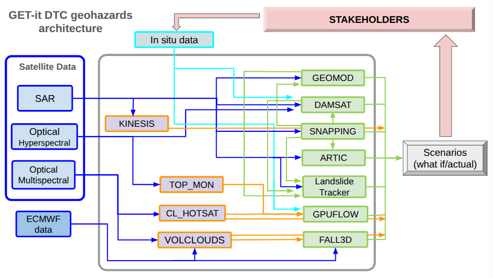
The Geohazards Digital Twin Component (DTC) is an advanced, modular platform designed to monitor, assess, and manage geological hazards such as earthquakes, volcanic activity, and landslides. By combining dynamic data streams—including satellite Earth Observation data, historical records, and in-situ measurements like GNSS and seismic readings—the system processes information across three hierarchical tiers, progressing from raw data ingestion to multi-dataset fusion and AI-driven predictive modeling. Fully integrated with both the Geohazards Exploitation Platform (GEP) and the Destination Earth Core Service Platform (DESP), the DTC enables researchers, decision-makers, and emergency teams to simulate "what-if" scenarios, streamline complex workflows, and obtain actionable recommendations for hazard mitigation.
Here below a comprehensive description of all Earth Observation (EO)-based services (Models-M), processing chains, and scenario/simulation models (Scenario Models-SMs) that will constitute the portfolio of the Geohazards Early Digital Twin Component (GET-it Phase 2) at the end of the project
Architectural & Operational Framework
At the completion of GET-it Phase 2, all services will be accessible via the Geohazards Exploitation Platform (GEP). The portfolio is structured into two main categories:
- EO monitoring & data processing Modules (M): Processing chains that ingest raw satellite observations (optical, thermal, SAR) and atmospheric data to produce analysis-ready monitoring parameters.
- Scenario Models (SMs): High-level numerical simulators and AI-driven tools that use output parameters from monitoring modules, satellite imagery, and meteorological models to generate predictive "what-if" scenarios.
Furthermore, service availability is categorized as follows:
- "as a Service" (On-Demand Execution): Full user execution with flexible, user-defined input parameters at any time (e.g., dynamically in response to new events) with interactive visualization of outputs within GEP.
- "as Test Cases" (Predefined Execution): Execution restricted to predefined scenarios with fixed, unchangeable timeframes and a preset, limited set of input data and Areas of Interest (AOIs).
- Integration Status: Services are either Integrated (fully embedded and executable on GEP cloud infrastructure) or Federated (externally hosted by the provider, with outputs continuously ingested into GEP via automated pipelines).
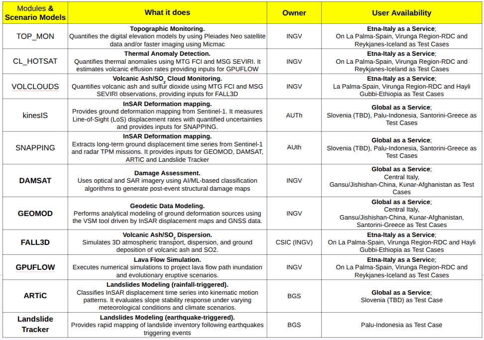
The table here below summarize the GET-IT Service portfolio:
The figure below shows the diagram illustrates the integrated architecture of the GET-it DTC geohazards system, which serves as a sophisticated workflow for monitoring and simulating geological risks.