Ministry of University and Research – Fund for Investments of Central Administrations
Action Lines: Research and innovation activities in research centers – Research and infrastructures
INGV Project: ‘Pianeta Dinamico (Dynamic Planet)-Working Earth’: Geosciences For The Understanding The Dynamics Of The Earth And The Consequent Natural Risks – PD
Responsible: Prof. Carlo Doglioni, INGV President
INGV Coordinators: Paolo Augliera and Guido Ventura
Objectives
1. To contribute in an innovative way to the storing, sharing and processing of data of all the possible observable parameters to identify the processes governing seismic, volcanic and environmental phenomena. These objectives will be achieved through the strengthening of the INGV observational networks and of the experimental and computational infrastructures. The PD results will make it possible to provide a new reference model for seismic, volcanic and environmental phenomena and their interconnections.
2. To know the anatomy and kinematics of Earth with special reference to the Italian-Mediterranean area. The final target is to understand the natural phenomenology and the associated potential risks to adopt more effective policies for the safety of the populations and the development of the socio-economic system.
3. To reconstruct the 3D structure and stratigraphy of the subsoil of Italy and seas through seismic profiles, seismic tomography, gravimetric and magnetic methods, monitoring of crustal movements by refining the GPS network, observation and mapping of the Earth from space; in addition, it is intended to create a hydrogeochemical network at a national level capable of detecting changes in the aquifers, which may record changes linked to terrestrial dynamics and which may prelude earthquakes and eruptions.
PD involves about 200 INGV researchers, technologists and technicians and it is organized in 10 Tasks activated in 2020 and 10 Projects activated in 2021.
The Tasks focus on research activities related to the topics of the three INGV Departments of Environment, Earthquakes and Volcanoes (Tasks A1, A2, A3, S1, S2, S3, S4, V1, V2, and V3)
TASK
ENVIRONMENT
Task A1 Atmospheric and Ionospheric activities in relation to large natural energetic phenomena
Task A1 Atmospheric and Ionospheric activities in relation to large natural energetic phenomena
Coordinator: Angelo De Santis
The topic of SINFONIA is the study of the circumterrestrial space in occasion of large energetic natural phenomena and is performed within 3 Work Packages (WPs).
A preliminary list of energetic natural phenomena has been listed in the frame of WP1, in particular earthquakes (world list M7+), volcanic eruptions, and magnetic storms.
Regarding the WP2, we started the study of ionospheric anomalies occurring in i) quiet or ii) disturbed geomagnetic conditions. The anomalies of the former type could be a manifestation of the Lithosphere-Atmosphere-Ionosphere coupling (LAIC) due to earthquakes or volcanic eruptions. The second type will be studied using standard and new algorithms (such as Machine Learning) to see, e.g., any correlation with phenomena associated with GIC, contributing to the understanding of space weather phenomena that are important for scientific knowledge and for the effects that they pnemeroduce on technological systems.
Within WP3, some single earthquake studies have been performed (e.g. M7.1 Ridgecrest and M7.2 New Zealand earthquakes, both occurred in 2019) for different physical quantities. 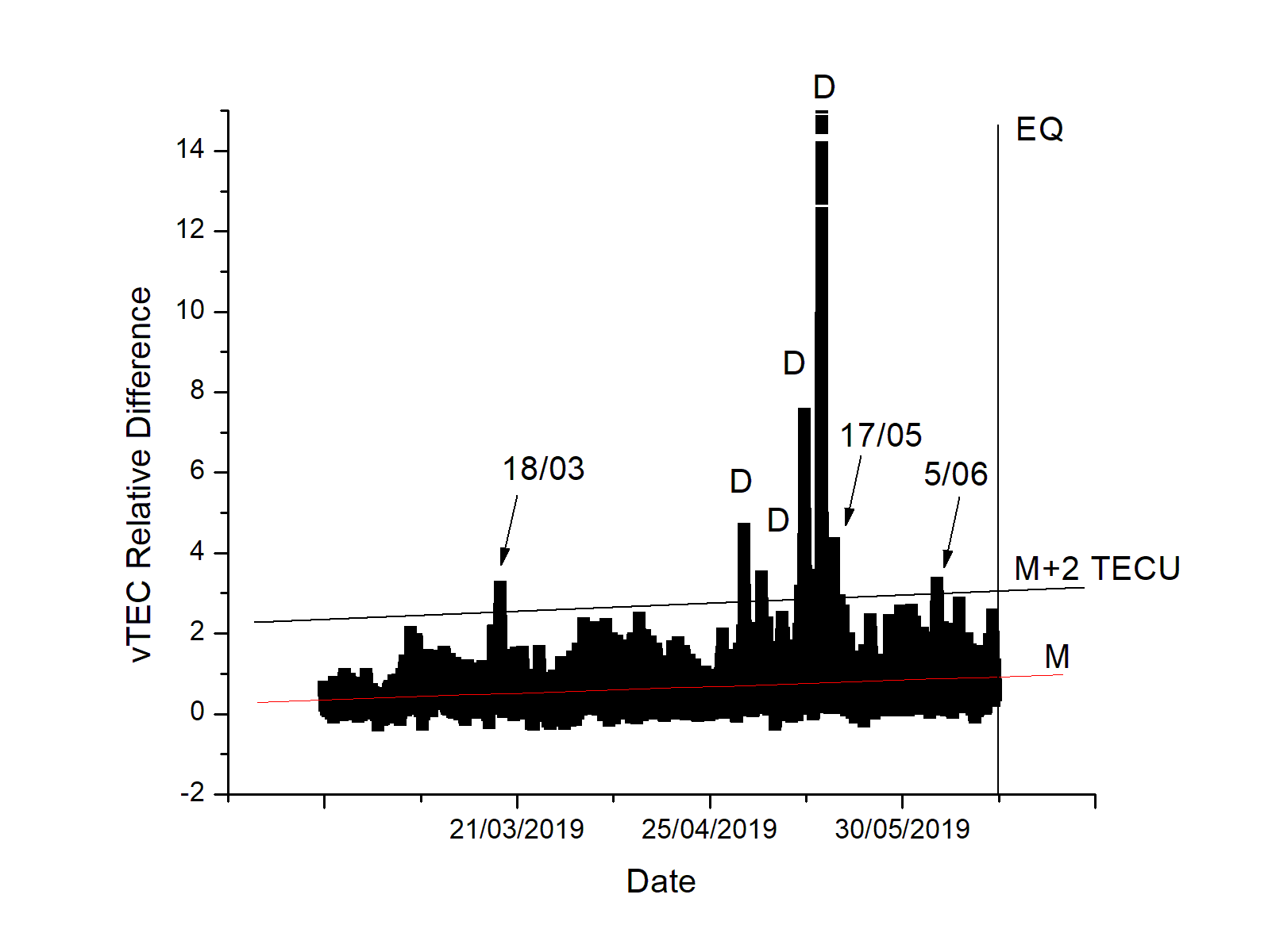
Figure Caption. Vertical Total Electron Content (vTEC) time relative difference variation between two GNSS stations for the case of the 2019 M7.2 New Zealand Earthquake (one station close to the epicentre, the other rather distant). The arrows indicate three anomalous days, likely related to an ionospheric perturbation associated with the preparation phase of the earthquake under study. D stands for disturbed ionosphere, so the corresponding anomalous days are not taken into account; M is the mean trend (red line) and M+2 TECU (black line) is the chosen threshold above which the value is considered anomalous; the vertical black line indicates the earthquake occurrence (22:55 UTC, 15 June 2019 ).
Task A2 Climate change, sea physics and chemistry, land-sea interactions
Task A2 Climate change, sea physics and chemistry, land-sea interactions
Coordinator: Marco Anzidei
8 samples for 40Ar/39Ar dating have been selected and are in process at the Rare Gas Laboratory of the Wisconsin University of Madison aimed at providing age constraints to the glacial terminations spanning the interval 0.6 - 1.3 Ma.
Results are available already for one sample which provided new age constraint on the glacial terminations VIII ands VII.
A survey about the main ocean climate monitoring indicators has been conducted containing also examples of geoportals handling information about climate change. Such a service could be implemented at INGV to display the information products deriving from environmental department multi-disciplinary research activities.
An application of sea level rise scenarios for 2100 as a consequence of climate change was carried out, following the criteria of the European projects SAVEMEDCOAST (www.savemedcoasts.eu) SAVEMEDCOASTS-2 (www.savemedcoasts2.eu). The methodology was applied to the coast of eastern Sicily, using GNSS, InSAR, LiDAR analyzes and IPCC-SROCC 2019 projections for RCP 2.6 and RCP8.5 climatic scenarios (www.ipcc.ch). The mean subsidence for this area is 7±2.5 mm/yr. In 2100, a high end of sea level rise is estimated at 1.12±0.13 m with a maximum coastal loss of 2,378 km2, is expected.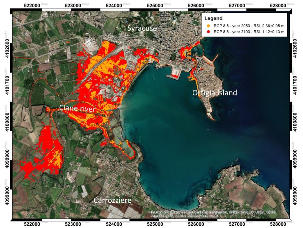
Sea level rise scenarios at Syracuse
Task A3 Innovation in geophysical-geochemical methodologies for the environment
A3 - Innovation in geophysical-geochemical methodologies for the environment
Coordinator: Maria Fabrizia Buongiorno
The geophysical and geochemical methodologies integrated with satellite observations represent very useful disciplines for environmental study aimed at understanding both natural and anthropogenic processes and their impact on the environment, human health and cultural heritage.
The A3 task is developed on 4 main activities (WP) and will compare data and methodologies acquired in different scales:
WP1 geophysical monitoring of the anthropic impact on the environment and cultural heritage
WP2 effects of climate change on fragile environments (coasts, etc.)
WP3 Geochemical monitoring for the study of geological methane emissions from anthropogenic structures and impact on climate.
WP4 Development of geochemical methodologies for the environment.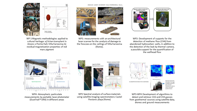
SEISMOLOGY AND DEFORMATION
Task S1 Earthquake nucleation, propagation and arrest: theoretical and experimental analyses. Seismic Source Complexity.
Task S1 Earthquake nucleation, propagation and arrest: theoretical and experimental analyses. Seismic Source Complexity.
Coordinator: Antonella Cirella-RM1
This task is focused on theoretical, observational and experimental analyses of the phenomena associated with the earthquake nucleation, propagation and arrest. A multidisciplinary experimental, numerical and observational approach is proposed through:
● the elaboration of robust and reliable rupture models able to describe the seismic source complexity; thus, providing useful hints to understand and correctly represent the real earthquake processes;
● the design of experiments (both in the laboratory and on a natural scale) that allow us to study in details and on short time scales the cause-effect relationships of signals associated with seismic instability, its nucleation and arrest;
● the development of multi-parameter monitoring networks and algorithms for detecting geophysical and geochemical signals associated with pre-, sin and post-seismic deformation.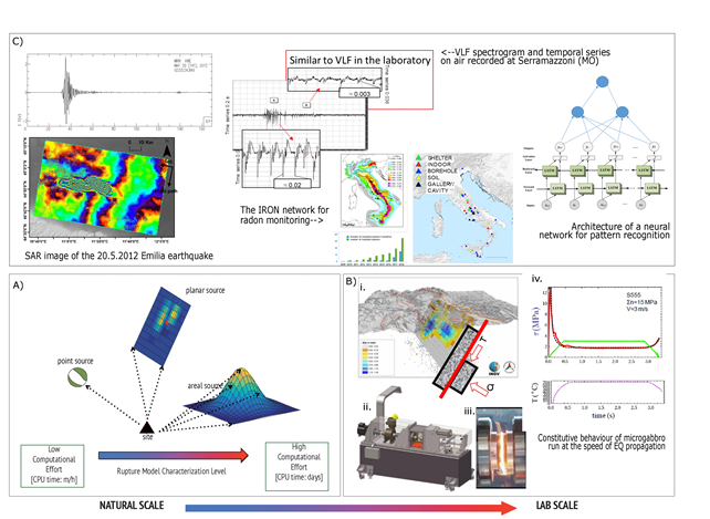
Earthquake Seismic Source: from natural to laboratory scale.
A) Numerical rupture models from: i. analysis of different types of data recorded during an event; ii. different types of parameterization and geometric fault surface configurations; iii. different forward and inverse modelling techniques. B) Laboratory simulations of earthquake mechanics, rock physics and signals associated with the nucleation and propagation of seismic slip. i. schematics of faults moving under frictional forces; ii. SHIVA (Slow to HIgh Velocity Apparatus) one of the most powerful earthquake simulators worldwide installed at HPHT INGV Rome; iii. flash heating and melting during high velocity experiments; iv. constitutive models of friction versus slip and temperature measurements; C) Earthquake Observables and Networks.
S2 3D structure of Italy from multidata analysis. Passive/active seismic, magnetometric, magnetotelluric, geoelectric, gravimetric imaging
S2 3D structure of Italy from multidata analysis. Passive/active seismic, magnetometric, magnetotelluric, geoelectric, gravimetric imaging
Coordinator: Filippo Greco
Task S2 aims to improve knowledge of the structure of the Italian area and neighbouring regions, in its deep and superficial, isotropic, anisotropic and density components. The main objective is to obtain a multiscale 3D model of the crust and upper mantle with a multidisciplinary approach, based on innovative analysis and inversion methods, integrating high quality and high spatial and temporal resolution data, ranging from seismic (active and passive) to magnetic, magnetotelluric, electrical and aerogravimetric prospecting. The main target will be achieved by means of a sequential approach, in which the study methodology is successively applied to several areas of specific interest over the whole peninsula, starting from central Italy (wide belt of the Lazio-Abruzzo Apennines, with a focus on the Fucino basin). In the frame of the project, a new National Gravimetric (G0) and Altimetric (H0) Reference Network will be implemented together with a dense multiparametric infrastructure in Northern Italy for geophysical and geochemical monitoring.
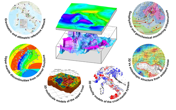
Figure caption: 3D structure of Italy from multidata analysis.
Task S3 Seismic attenuation and variability of seismic motion
Task S3 Seismic attenuation and variability of seismic motion
Coordinator: Giovanni Lanzano
The objective of the Task S3 is the modelling of spatial and temporal variations of seismic motion in relation to attenuation, its regional characteristics and the evolution of seismic sequences. S3 consists of 4 Work Packages (WPs): WP1 concerns the study and modelling of spatial/temporal variation of seismic motion using seismometric, macroseismic intensities and damage data; WP2 focuses on modelling the spatial and temporal variation of seismic motion, relating anelastic and scattering attenuation to the preparation phase of large Central Apennine earthquakes, to the co-seismic phase, and to the post-seismic phase; WP3 deals with the quantification and mapping of the attenuation parameters in the tectonic areas of eastern Sicily, including the volcanic area of Mount Etna; WP4 assesses the impact of regional motion models on the probabilistic seismic hazard estimates in the study areas of WP1 and WP3.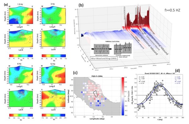
a) vertical sections obtained from the 3D mapping of the Q-coda along the sections crossing the summital craters of Mount Etna; b) seismic attenuation variations as a function of time and frequency, before and during the 2016-2017 Central Apennine seismic sequence; c) systematic path effects observed from non-ergodic ground motion model residuals of Fourier Amplitude Spectrum ordinates at 10Hz; d) azimuthal dependence of rupture-directivity effects observed from source-, site- and path- corrected residuals of Fourier Amplitude Spectrum non ergodic ground motion model at 5Hz.
S4 Short and long term crustal deformations associated with earthquakes, hydrological, and gravitative processes, and large-scale geodynamics using SAR and GNSS data.
S4 Short and long term crustal deformations associated with earthquakes, hydrological, and gravitative processes, and large-scale geodynamics using SAR and GNSS data.
Coordinator: Christian Bignami
By now SAR and GNSS data have extensively demonstrated their capability to effectively study and model crustal deformation processes at single fault or local faults system scales. Nevertheless, their use in modelling large-scale geodynamic processes is still limited and can be widened by integrating numerical methods with increased data availability. Thus, the objective of this Task is twofold: a) exploiting up-to-date 3D surface velocity maps derived by the most recent SAR missions (e.g. the Sentinel-1 operated by the European Space Agency) and new GNSS measurements; b) constraining the numerical models with dense surface velocity and displacement maps. This approach is expected to increase our understanding of different tectonic processes and related forces, mainly relying on surface deformation data.
Three test cases have been selected: Eastern Alps, Central Italy and the Calabrian Arc.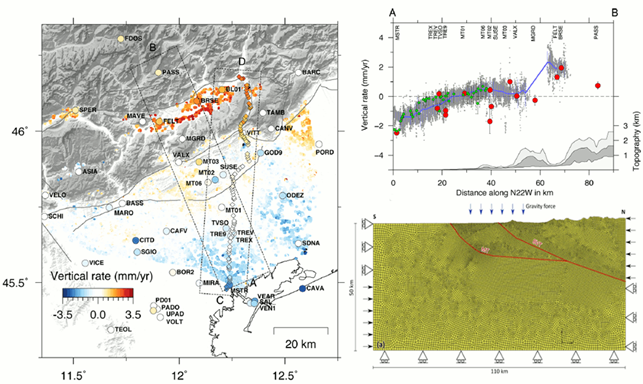
Left panel: vertical velocity field from InSAR data decomposition (dots), from GNSS measurements (circles) and from the IGMI leveling data (diamonds). Right panel: cross sections of vertical velocities along the A–B profile (top), and the corresponding mesh grid of the 2D numerical model (bottom). Reference: Anderlini et al, 2020, New insights into active tectonics and seismogenic potential of the Italian Southern Alps. Solid Earth.
VOLCANOES
V1 3D-4D structure of volcanoes using geophysical exploration techniques including seismic arrays, geoelectric and magnetotelluric, magnetic surveys. Inversion and imaging techniques - study of the subsoil of the Phlegraean Fields in the Solfatara-Pisciarelli areas also in relation to the current dynamics
V1 3D-4D structure of volcanoes using geophysical exploration techniques including seismic arrays, geoelectric and magnetotelluric, magnetic surveys. Inversion and imaging techniques - study of the subsoil of the Phlegraean Fields in the Solfatara-Pisciarelli areas also in relation to the current dynamics
Coordinator: Antonio Troiano
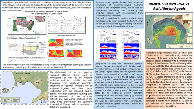
The ongoing activities, mainly of methodological nature, are focused on the search for innovative techniques aimed at integrating coordinated geophysical surveys at different scales with geodetic and geochemical observations. Researches are developed on selected volcanic areas, as the Campi Flegrei caldera (CFc), Vesuvio, Ischia and Vulcano. Geophysical surveys include Electrical Resistivity Tomography, Time Domain and Spectral Induced Polarization, active and passive seismic, multiparametric and integrated geodetic observations, gravimetric and magnetic field. The geochemical activities regard the identification, characterization and graphic representation of the main hydrothermal and/or magmatic degassing areas (subaerial and submarine), as well as the definition of the main magmatic component and melt/fluids contamination in the plumbing system. All multidisciplinary and integrated information will contribute to an holistic modeling of the magmatic processes and the caldera inner structure.
V2 Fluid-rock interactions in volcanic environments and their implications on the dynamics and unrest of volcano-hydrothermal systems
V2 Fluid-rock interactions in volcanic environments and their implications on the dynamics and unrest of volcano-hydrothermal systems
Coordinator: Gilda Currenti
Task V2 is dedicated to the study of volcano-hydrothermal systems. The aim is to deepen the knowledge on the complex fluid-dynamic processes and physico-chemical mechanisms that regulate their evolution and lead to volcano unrest or to eventual quiescence. The development of multidisciplinary methodological approaches aims at the integration of analytical results from minero-petrological investigations on rocks reservoir and observational data from geochemical and geophysical monitoring, into fluid-dynamic and physico-chemical models developed to describe the dynamics of volcano-hydrothermal systems. Applications of the methodological approaches are tested and validated at two active Italian volcanoes, Campi Flegrei and Vulcano, and at La Soufrière de Guadeloupe.
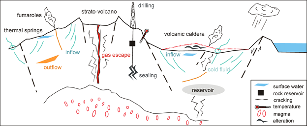
Schematic model of a volcano-hydrothermal system governed by fluid transport processes and feedback mechanisms between thermodynamic, mineralogical and geochemical transformations.
V3 Preparation and dynamics of large eruptions
V3 Preparation and dynamics of large eruptions
Coordinator: Matteo Cerminara
The task aims at studying the dynamics, the impact and the observables of large volcanic eruptions, focusing on the 79 AD Vesuvius explosive eruption example, and on its distal and ultra-distal deposit phases. This includes the reconstruction of the pre-eruptive dynamics, of the effects of the numerically simulated eruptions (fallout and pyroclastic density currents) and of the subsequent phenomena on the territorial environment. The simulations, based on reviewed input parameter ranges at the vent level, are analyzed by comparing the different considered scenarios with observations. Observables available nowadays (both from ground and satellites) are defined and reproduced synthetically with the 4D multiphase model coupled with a validated radiative transfer model. The methodology is used to calibrate simpler and faster models useful for probabilistic hazard assessments. Finally, dissemination material will be produced.
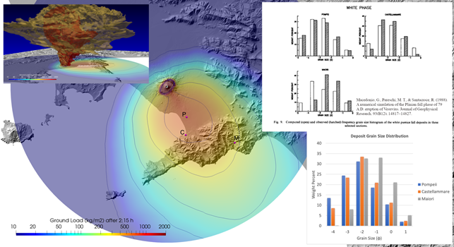
Numerically simulated deposit ground load represented with the colormap and the contour lines drawn in correspondence of 10, 50, 100, 250, 500 kg/m2 (and, not visible, 750, 1000, 1500, 2000 kg/m2), vertical view, 2:15 h after the beginning of the eruption. The upper left inbox shows mass fraction isosurfaces of 16 mm lapilli (red) and 1 mm ash (yellow) above the Vesuvian and Neapolitan area. The two inboxes on the right show the grain size distribution of the deposit in Pompeii (P), Castellammare (C), and Maiori (M). The upper one is from Macedonio et al. (1988), showing the comparison of the observation (hatched columns) with the deposit grain size distribution obtained with an ash dispersion model (open columns). The lower inbox shows the results computed in the present numerical simulation.
Projects refer to five main themes and cover cross-fields, multidisciplinary activities including multi-hazard analysis. PD has active collaborations with Italian and international universities and research centers.
THEMES
- Sea-land interactions
- Relationships among volcanoes, eartquakes, climate and space
- Deformation of the lithosphere
- Evolution of the composition and rheology of the crust, relations between fluids and deformation
- Monitoring and hazards:from data analysis to models, early-warning mechanisms and multi-hazard/multi-risk estimates
The 10 Projects are ATTEMPT, BESTCaFE, CHOPIN ,HEAVEN, KINDLE, MYBURP, PANACEA, SERENA, SOME, and TIFEHO.
PROJECTS (2021-2023)
ATTEMPT:integrATed sysTEm for Mutli-hazard from sPace over mediTerranean
integrATed sysTEm for Mutli-hazard from sPace over mediTerranean
PI Claudio Cesaroni
The ATTEMPT project aims at realizing a demonstrator of an integrated system capable of collecting multi-parametric space borne data to monitor different natural hazards over Mediterranean. The system will monitor and investigate space weather, landslides and subsidence phenomena, volcanic unrest and volcanic clouds by means of data from GNSS, SAR and optical/IR instruments on board of satellites to investigate the possible interconnections among these geo-hazards on different spatial and temporal scales.
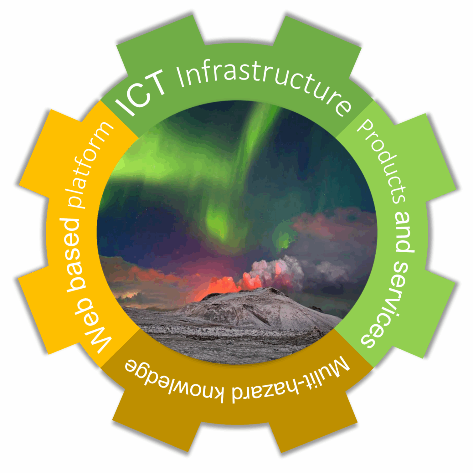
Infographic illustrating the main objectives of the ATTEMPT project
CHOPIN: volCano-atmospHere-iOnosPhere connectIoN
volCano-atmospHere-iOnosPhere connectIoN
PI Salvatore Roberto Maugeri
The objectives of this theme are:
- Improve the quality and sensibility of the electromagnetic signals that are being collected around Etna volcano, both by using better sensors and by lowering the artificial noise due to human activities.
- Improve the Signal to Noise ratio of ground-based measurements, allowing the detection of weak signals otherwise hidden in noise.
- Integrate atmospheric and ionospheric data observed by satellites, for example magnetic and plasma data acquired by European Space Agency’s Swarm constellation.
- Enhance the sensitivity, by coupling with geochemical ground measurements. This will allow us to better investigate the correlation between seismic or volcanic events and electromagnetic perturbations.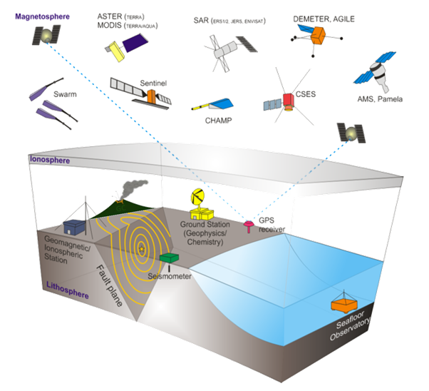
Integrated multiparametric platform system from lithosphere to atmosphere and ionosphere. The same system shown here for a potential earthquake observational system can be extended also to a volcano.
HEAVEN: Hazard from EtnA Volcanic EmissioNs
Hazard from EtnA Volcanic EmissioNs
PI: Salvatore Giammanco
Objectives: The project is aimed at creating a multidisciplinary group of scientists that will study the real incidences of neurological diseases such as Multiple Sclerosis, Amyotrophic Lateral Sclerosis together with Primary Brain Tumors in the Mt. Etna area, to be correlated with volcanic emissions of technology-critical elements and systemic toxicant elements. Geochemical and biological models will be developed to understand how volcanogenic trace elements and radon gas emitted both during periods of volcanic quiescence and during eruptions reach living beings and accumulate in their tissues. Elemental fluxes released from the volcano to the environment will be estimated and thermodynamic studies will be carried out on the speciation of those trace elements found in greater amounts into human tissues. Lastly, the health hazards related to volcanic emissions of potentially harmful trace/radioactive elements will be assessed.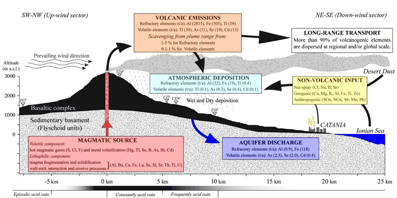
KINDLE: KINematics and Deformation of the Alpine LithosphEre
KINematics and Deformation of the Alpine LithosphEre – KINDLE
PI Paola Baccheschi
KINDLE project focuses on the Alpine area to capture the link between the processes acting below and within the lithosphere and the geological surface features. Independent approaches will be adopted: seismic anisotropy and tomography, receiver function, gravity anomaly inversion, geodetic velocity field corrected for GIA, earthquake-induced stress variations and active fault kinematics. The analysis of existing and new data at different scales will help to catch: the mantle flow pattern in the asthenosphere and lithospheric-scale shear zones; the depth of the Moho and other interfaces, and shear wave velocity profiles; the three-component ground displacement time-series, horizontal-vertical velocities and strain-rates; the state of crustal stress. KINDLE will combine these results to advance the knowledge on the mechanisms that control the lithospheric deformation beneath the Alps and to understand whether the mantle and crust deform coherently or otherwise.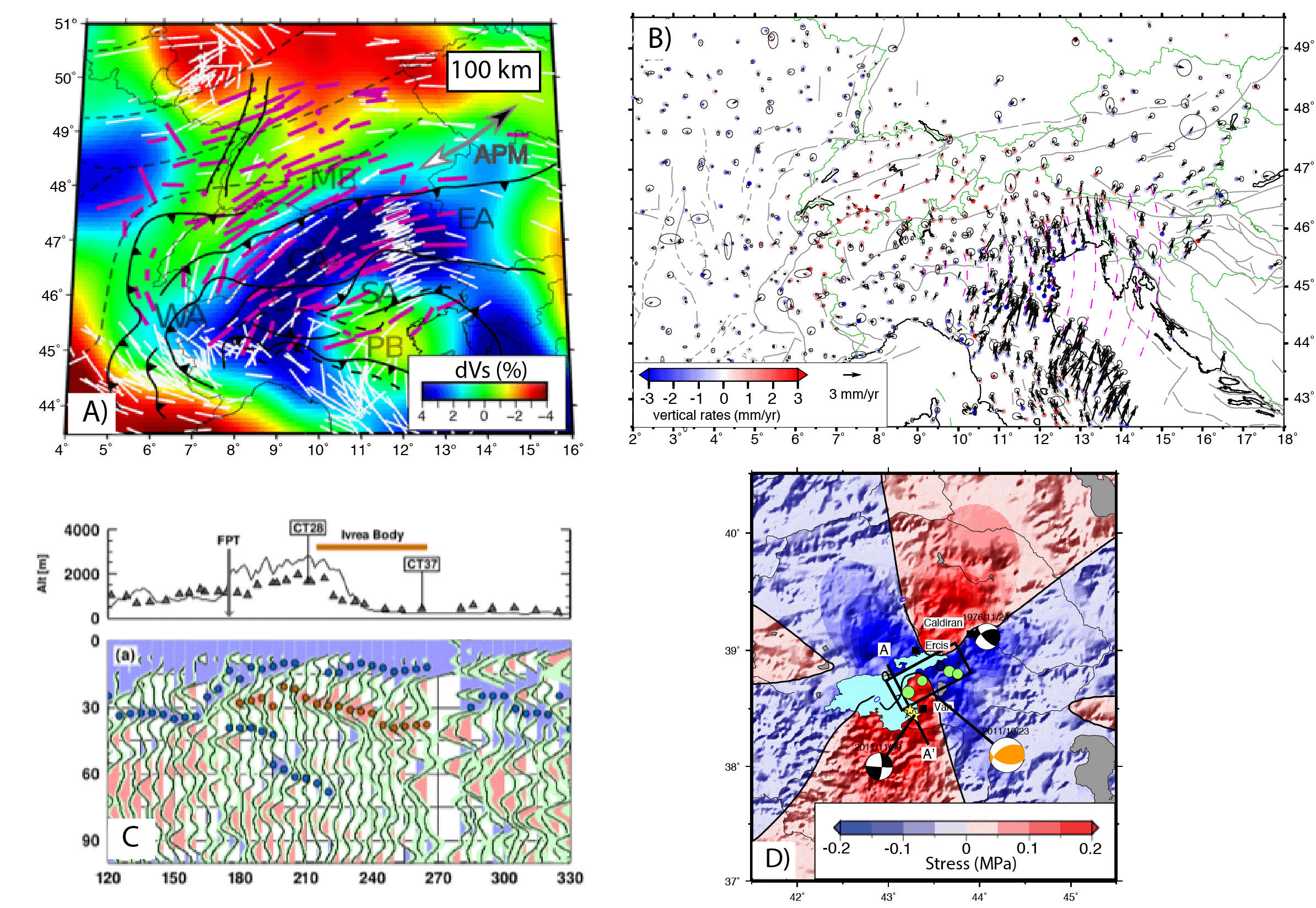
Main methods and products. A) Map of azimuthal seismic anisotropy from shear wave splitting superposed over the P-wave tomography model at 100 km (Petrescu et al., 2020); B) Horizontal (arrows) and vertical (color dots) velocities w.r.t. Eurasia (Serpelloni et al., in prep); C) Angular harmonic decomposition of the receiver function dataset beneath the Ivrea body (Salimbeni et al., under revision to JGR); D) example of CFF variation we propose to produce in this project (here is shown the CFF variation produced by the 23rd of October 2011 Mw 7.1 Van (Turkey) mainshock; Akinci & Antonioli, GJI, 2013).
MYBURP:Modulation of hYdrology on stress BUildup on the IRPinia Fault
Modulation of hYdrology on stress BUildup on the IRPinia Fault
PI Nicola D’Agostino, ONT Grottaminarda
The project MYBURP will use a multidisciplinary approach (geodesy, seismology, geochemistry) to probe the response of the Irpinia Fault System to stress modulations caused by recharge/discharge phases of regional karst acquifers. Using geodetic, seismological and geochemical measurements associated to transient episodes of non-linear strain buildup, we will contribute to the characterization of the frictional, elastic and hydrological properties of the Apennines seismogenic faults.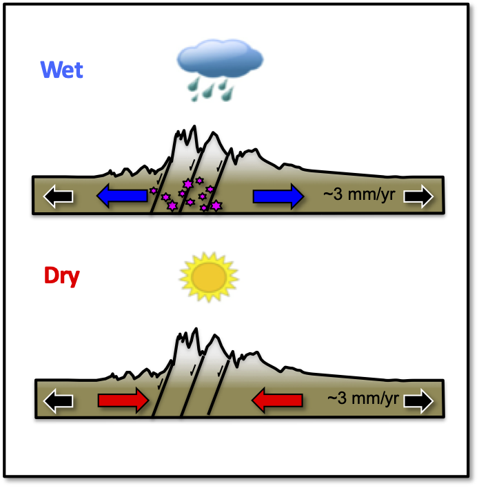
SERENA:Space weather and climate change: the Solar wind - Earth’s magnetosphere Relationships and their Effects on ioNosphere, and upper and lower Atmosphere at various temporal and spatial scales
Space weather and climate change: the Solar wind - Earth’s magnetosphere Relationships and their Effects on ioNosphere, and upper and lower Atmosphere at various temporal and spatial scales (SERENA)
PI: Mauro Regi
Space Weather events are of great interest for their effects on atmospheric environment and technological systems. At high latitudes where the Sun-Earth’s interactions take place, precipitating energetic particles from the magnetosphere could change the atmosphere and lower ionosphere parameters leading to physical and chemical processes characterized by different temporal and spatial scales. In the ionosphere/thermosphere, space weather events could cause a degradation of HF communications and positioning accuracy in devices using GNSS signals, and determine a stronger air drag which requires recalculation of satellites orbits.
SERENA project aims to improve the monitoring and forecasting of the geomagnetic activity and the response of ionosphere, thermosphere and lower atmosphere systems to external forcing, leading to a better knowledge of dynamic circumterrestrial environments.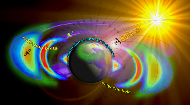
SOME: Seismological Oriented Machine lEarning
Seismological Oriented Machine lEarning
PI: Carlo Giunchi
SOME is aimed at developing machine learning (ML) techniques for a better understanding of Italian seismicity, local and regional attenuation properties, ground shaking, and for the optimization of existing seismic networks deployment. SOME will provide properly organized, high quality, public datasets extracted from the large amount of seismic recordings of INGV, organized in a suitable and ready to use format for intensive ML analysis. These datasets will serve for benchmarking existing methodologies and for testing novel approaches. SOME goal is to build a community of scientists specialized in ML approach to the analysis of seismic data.
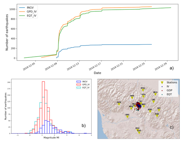
Exploitation of the seismic sequence following the MW 4.5 Mugello earthquake (12-09-2019) using two different phase pickers based on machine learning: GPD (Ross et al., 2018) and EQT (Mousavi et al., 2020). a) Comparison of the time evolution of the sequence from INGV bullettin(INGV) and from phase picks obtained by machine learning (GPD and EQT). The total number of detections increases by about a factor 4. b) same as a) but for the ML distribution. c) Map locations of the earthquakes.
TIFEHO: Trachytic Ignimbrites magma-chambers Formation and Evolution in the pre-HOlocene history of the Campania volcanic area. Implications on magmatic processes, eruption dynamics, caldera collapse and resurgence
Trachytic Ignimbrites magma-chambers Formation and Evolution in the pre-HOlocene history of the Campania volcanic area. Implications on magmatic processes, eruption dynamics, caldera collapse and resurgence
PI: Sandro de Vita
The main goal of the TIFEHO project is to reconstruct the structure, growth and evolution of the magmatic feeding system/s of some of the largest magnitude eruptions originated from the Campania Volcanic area (Fig. 1), such as the Campanian Ignimbrite and the Mount Epomeo Green Tuff eruptions dated at 39.88±0.17 ka and 56.0±1.0 ka, respectively, and some ignimbrite eruptions that shortly predated these two events. We will focus on the lesser known aspects of the eruption dynamics, and specifically on the timescales of both magma chamber (storage, mixing/mingling and refilling), and conduit (ascent) processes, in order to understand the evolution of the volcanism in the Campania region, and the mechanisms that allow the growing of large magma reservoirs and then the occurrence of high-magnitude eruptions, caldera collapse, syn-collapse flow generation, fall and ash generation and dispersal, and caldera resurgence.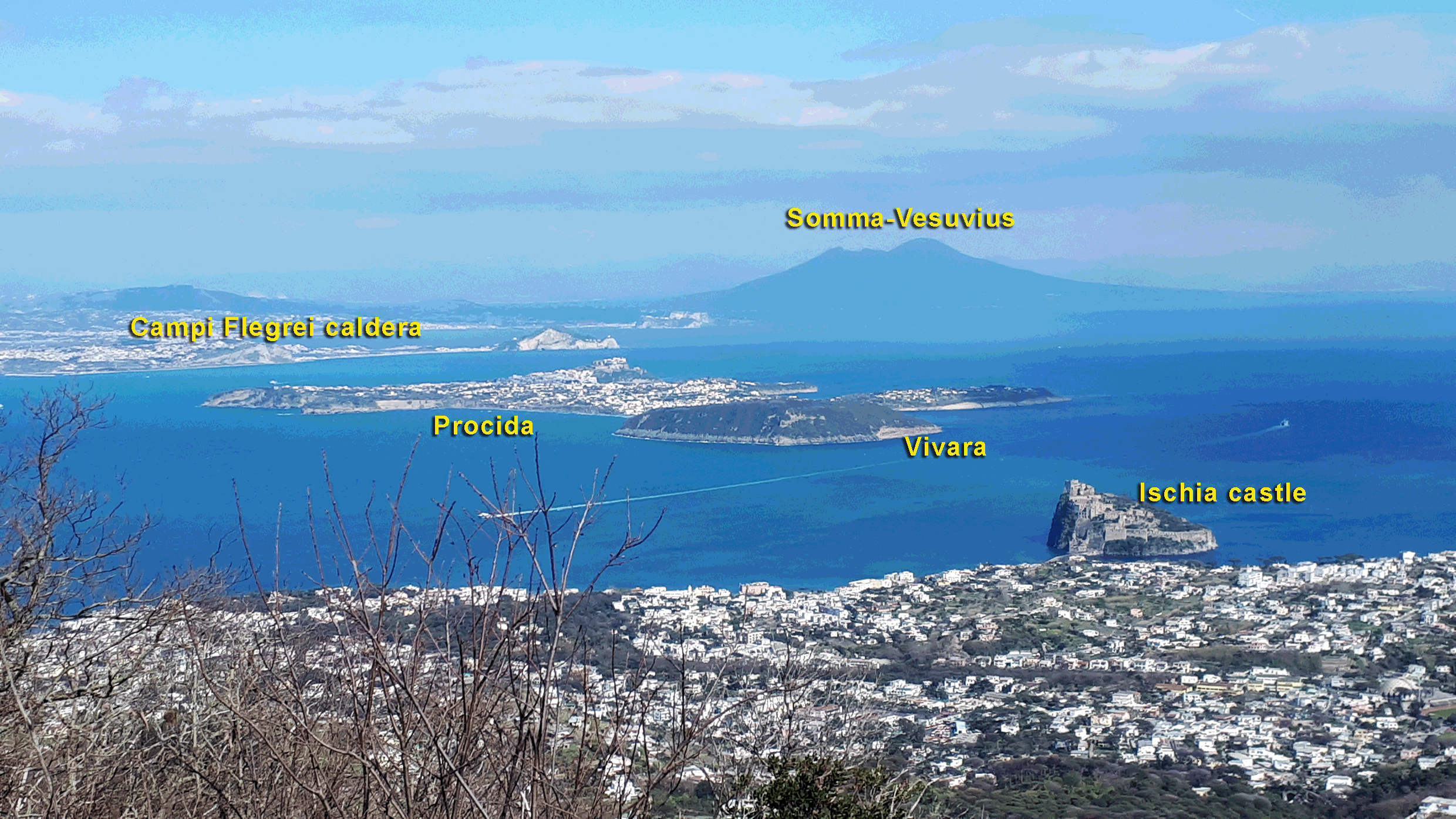
PROJECTS (2023-2025)
The SESAR project -Space Weather Effects on South Atlantic Anomaly Region
Abstract SESAR Project
The SESAR project (Space Weather Effects on South Atlantic Anomaly Region) aims to investigate the atmospheric and near-Earth space dynamics in the South Atlantic Anomaly region (SAA). In the framework of SESAR, a deeper study on the impact of the Sun’s activity on the Earth’s environment and circumterrestrial regions will be conducted, focusing on a particular region where the intensity of the Earth’s magnetic field significantly decreases. This large anomaly area of the field strength currently extends from the East Pacific to South Africa, and it is characterised by high radiations close to the Earth's surface due to the deeper penetration of charged particles in the Earth’s atmosphere. The dip of geomagnetic field results also in a marked increase in the electron density at heights of about 300 km. Such phenomena could represent a critical issue for satellites and other objects orbiting at Low Earth Orbit (LEO) altitude for increased drag effect; furthermore, communications can be strongly disturbed because of the induced currents in transmission lines during geomagnetic storms. Hence, there are a variety of reasons for which the ionosphere-thermosphere response of the SAA region is an important research topic for Space Weather purposes. ESA Swarm satellites data will be used for reconstructing the SAA electron density, magnetic topology and dip equator morphology, together with their time evolution from 2015 till present. The analysis of data coming from ground-based instruments, such as ionosondes, magnetometers and GNSS receivers, will also play an important role in the investigation of the dynamics of such a peculiar area, providing information on the corresponding evolution of SAA.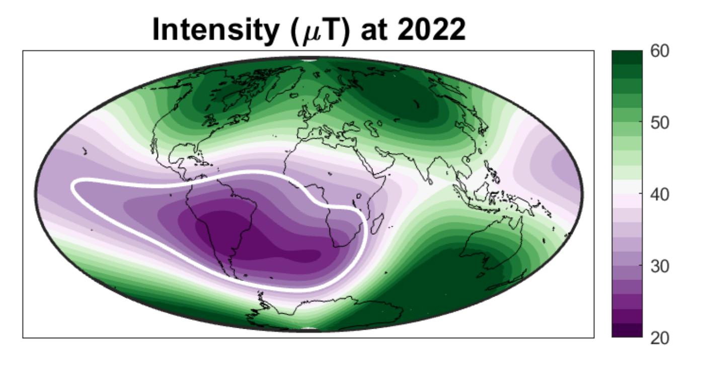
CHIOMA: Cultural Heritage Investigations and Observations: a Multidisciplinary Approach
CHIOMA: Cultural Heritage Investigations and Observations: a Multidisciplinary Approach
PI Aldo Winkler
Cultural heritage (CH) encompasses properties and sites of archaeological, historical, cultural, artistic and religious significance as well as unique environmental features and cultural knowledge. Cultural heritage sites are under increasing pressure from environmental pollution and climate change, infrastructure development, mass tourism, vehicular traffic, and other threats. In order to preserve CH, the International Centre for the Study of the Preservation and Restoration of Cultural Property promotes the approach of “preventive conservation”, defined as: “all measures and actions aimed at avoiding and minimising future deterioration or loss. These are carried out within the context or on the surroundings of an item, but more often a group of items, whatever their age and condition. These measures and actions are indirect – they do not interfere with the materials and structures of the items. They do not modify their appearance”. In this project, various state-of-the-art non-invasive methodologies used in Earth Sciences will be applied to the preservation and restoration of CH, for addressing multidisciplinary environmental services to the protection, enhancement and investigations of fine arts, including new insights for outlining the impact of anthropic activities in urban environments, in the key of fostering Cultural Ecosystem Services though scientific and technical developments and leading a new level of cooperation between INGV and cultural heritage, science of life and chemistry Institutions, scientists and operators. The cultural partners of the project are Accademia Nazionale dei Lincei, Parco Archeologico del Colosseo and Museo Nazionale Romano in Rome, Collezione Peggy Guggenheim in Venice and, as research partners, University of Siena, Laboratorio di Diagnostica per i Beni Culturali di Spoleto (LabDia), Aix-Marseille Université in Marseille, IRET-CNR, Centro Espigas del Instituto de Investigaciones sobre el Patrimonio Cultural and Universidad Nacional de San Martín in Buenos Aires.
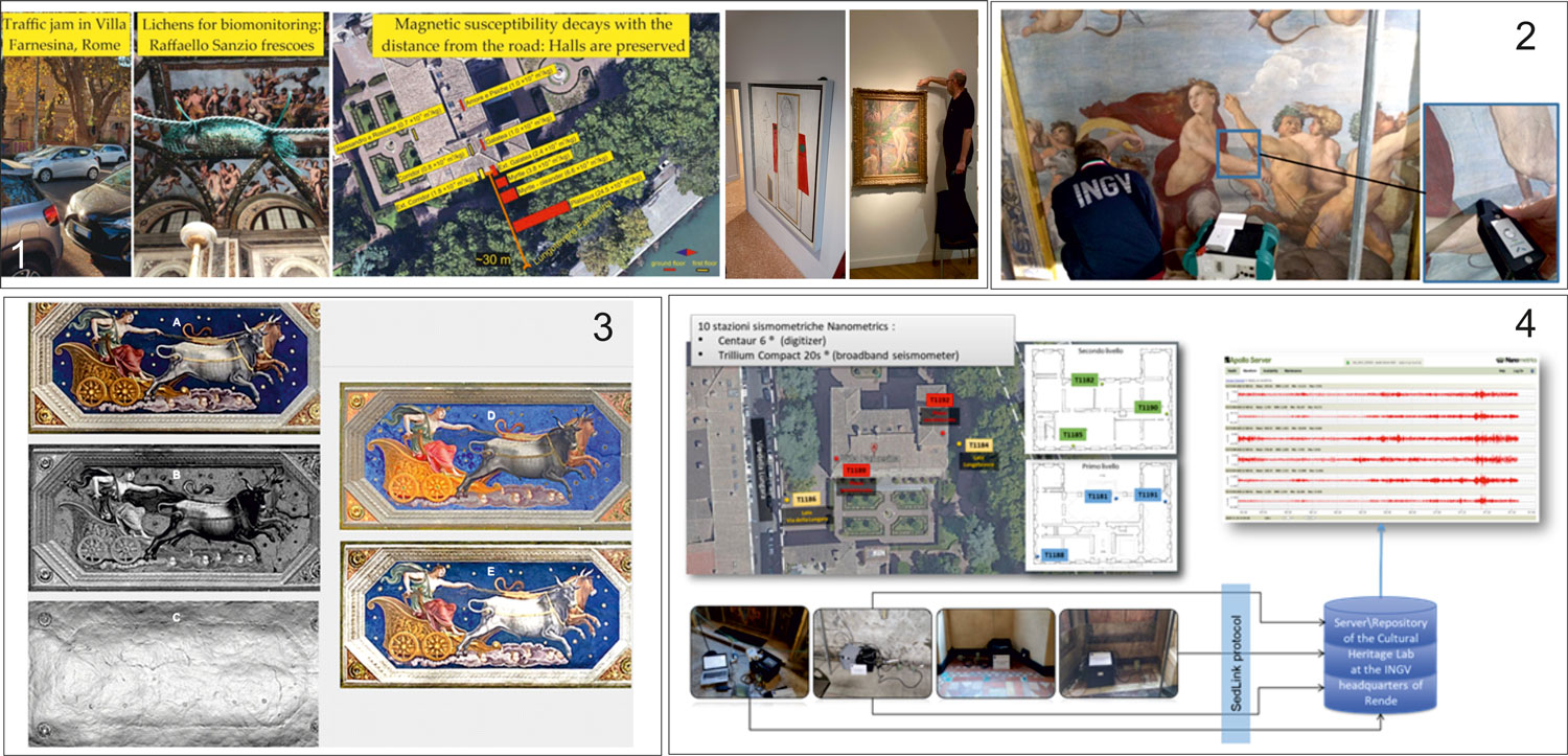
Multidisciplinary investigations applied at Villa Farnesina, Roma: (1) Lichens exposed in and around the Villa, for assessing the role of the distance from the road and of the ecosystem services provided by trees in mitigating the impact of vehicular emissions. The same experiment at Collezione Peggy Guggenheim, Venice and at Museo Nacional Bellas Artes, Buenos Aires; (2) Surface spectroscopy for the characterization of Raphael’s frescoes (3) Images extracted from the 3D model of the Panel depicting Elice: A) Color image B) Intensity image (C) morphology D) Combination of the intensity and colors (E) Combination of the morphology and colors 4) Functional scheme of the temporary monitoring of Villa Farnesina performed through a seismometer network for characterizing the vibration level on the different floors.
DYNAMO - DYNAmics of eruptive phenoMena at basaltic vOlcanoes
DYNAMO - DYNAmics of eruptive phenoMena at basaltic vOlcanoes
PI Luciano Zuccarello, INGV Sezione di Pisa
Volcanic eruptions have social and economic impacts at scales from local to global. In more severe cases they can affect climate on a planetary scale and threaten the population's life. Damage to buildings, crops, telecommunications, and disruption of aviation traffic, are frequent occurrences. The mitigation of volcanic risk requires the ability to understand monitoring data that are recorded in real-time before the unrest and during the eruption, and to quantify the processes that control the intensity, style and timing of eruptions.
Sibilla -
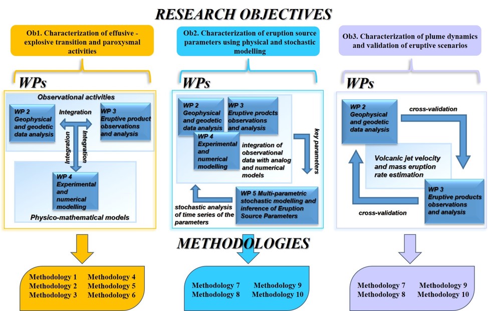
EMOTION is a three-year project (2023-2025) that aims to perform a geochemical characterization of geothermal manifestations in central-northern Italy. In addition, the project will provide a reliable and public national web portal that includes the manifestations already examined in the south of the country. The goal of the EMOTION project is to increase the knowledge about the geothermal resources of the Italian territory, as well as to support the geothermal exploration for low (T less than 100°C), medium and high temperature (T greater than 150°C) resources, especially in the early phases of the potential assessment. This concept is particularly relevant for the countries with high-quality geothermal resources, such as Italy, where the resources are currently under-exploited relative to the large geothermal potential. Four work packages (WPs) make up the Project’s structure: - WP1 collection and critical review of published geochemical data; - WP4 creation of a web portal of geothermal manifestations in Italy. Several INGV Sections (Rome1, Bologna, Naples, and Palermo), Universities of Florence, Perugia, Calabria, and Genoa, and the CNR-IGG are involved in the EMOTION Project. For further information visit the EMOTION website NEMESIS NEar real-tiME results of Physical and StatIstical Seismology for earthquakes observations, modeling and forecasting PI: Giuseppe Falcone INGV Sezione Roma1 NEMESIS is a three-year project (2023-2025) that aims to enhance statistical seismology and earthquake forecasting on Italian territory with a focus on volcanic regions like Etna and Vesuvius. The goal of the NEMESIS project is to standardize and compare existing statistical techniques, identify their strengths and weaknesses, and determine optimal methods for specific studies. Additionally, the project intends to develop physics-based models by using deformation data, Coulomb Failure Function stress computation, and rate and state-dependent friction. Special attention will be given to seismic activity in Italian volcanic zones, previously understudied in Operational Earthquake Forecasting (OEF) applications. New testing methods will be employed to evaluate model's performance and potential combinations. Furthermore, NEMESIS aims to establish an INGV website for real-time access to seismic analysis products, including estimates of seismic parameters, processed earthquake catalogs, statistical results, and performance tests. This platform seeks to enhance forecasting accuracy and accessibility by providing comprehensive data dissemination and analysis tools to researchers. Four work packages (WPs) make up the Project’s structure: - WP1 Data quality analysis; Several INGV Sections (Rome1, Rome2, ONT, Bologna, Naples, and Catania), Universities of Bologna, Bergamo and Campania(“L. Vanvitelli”), and the CNR and OGS are involved in the NEMESIS Project. For further information, visit the NEMESIS website.(under construction) SMEEGOL - historical Sources, Mineral microanalysis, Experimental pEtrology and numerical modellinG to unravel the precursor phenomena Of voLcanic eruptions: the case of the neapolitan volcanoes PI Ilenia Arienzo, INGV Osservatorio Vesuviano The SMEEGOL project focuses on studying historical volcanic eruptions in the Neapolitan area, including Campi Flegrei, Ischia Island, and Mt. Vesuvius. Here are the main goals and methodologies of the project: Specific Objectives of the Project are: Implications for Volcanic Hazard Assessment: The data generated by the SMEEGOL project will provide critical information for volcanic hazard assessment in the Neapolitan volcanic area. This knowledge can help in understanding the future behaviour of active volcanoes based on observed unrest phases. Communication and Description of Volcanic Events: The project also aims to explore how the communication and description of volcanic events have changed over time, depending on the audience and social status of the authors. This analysis covers the period from 1631 A.D. to 1944 A.D. and reflects the evolving understanding and perception of volcanic phenomena and their impact on humans and the environment. In summary, the SMEEGOL project seeks to advance our understanding of historical volcanic eruptions in the Neapolitan area, using a multidisciplinary approach to better assess volcanic risks and improve early warning systems. Additionally, it explores how the communication of volcanic events has evolved over time. UNITARY: Earthquake harbingers in the world from ground to space, with particular attention to Italian territory Earthquakes of magnitude six (seven) and above occur about once or twice a decade in Italy (two or three every year in the world). They often claim hundreds of lives in Italy (thousands in the world), cause extensive economic losses and can trigger environmental catastrophes. Science communities and operational agencies are struggling as to how to provide early detection of such events and reduce the loss of human lives and property. We propose a novel approach to utilize observations from multiple satellite and ground observations, data assimilation models to detect and reveal pre- and co-seismic signals that have been found in the past to originate from large earthquakes. We will study worldwide cases, to transfer our understanding to Italian case studies, in particular. This proposal represents an innovative study exploring a new physical hypothesis about the generation of signals caused by increasing stress in the Earth’s crust prior to an earthquake. The project intends to unify and integrate the data analyses, under the umbrella of a unified scenery where the preparation of the earthquake and its coupling with the above geolayers are central to the effects seen in lithosphere, atmosphere and ionosphere (Figure 1 shows the case study of 2019 M7.2 Kermadec Islands earthquake). Moreover, this project aims to advance Italian (and INGV) existing capabilities of early warning and risk mitigation for strong earthquake events, and can support future operational developments. Volcanological – VT. Focused on subtheme 2 (Characterization of the unrest dynamics of volcanoes and eruption forecasting) Titolo: WUnderVul - Toward a Wider Understanding of Vulcano PI: Gianfilippo De Astis - INGV Sezione Roma1 WUnderVul is a volcanological 3-year project (2023-2025) focused on the comprehension of those conditions and processes that control the transition of the Vulcano system (i.e. La Fossa cone and caldera) to different states of activity, passing through variable unrest phases. In particular, the project aims to achieve a better understanding of the dynamics of the hydrothermal system and possible phreatic eruptions, as a renewal of volcanic activity approaches. The specific goals of the WUnderVul project can be summarized as follows: Four work packages (WPs) make up the Project’s structure: - WP1 - Data acquisition and organisation (Coord. P. Madonia), with 5 Tasks; - WP4 - Coordination, Workshop & Dissemination (Coord. C.Federico and G. De Astis). After the beginning of the project, due to some unpredictable but necessary changes in the organization chart, WP3 and WP4 have been merged. Several INGV Sections (Catania, Palermo, Roma1, Bologna, Naples and Pisa), Universities of Bologna, Bari, Monaco, Pisa, Napoli and Caserta, and the CNR-IGAG are involved in the WUnderVul Project. For further information visit the WUndeVul website (under construction) (A) The WUnderVul WPs. (B) Scientific growth based on the exchange of information among data (WP1), physical modelling and laboratory experiments (WP2) and interpretative frameworks (WP3), nested into a multiple expert framework (WP4). The PD activities will include the creation of a large infrastructure devoted to the storage of large datasets and virtual machines for the implementation of advances, high-performance calculation resources. PD OUTPUTS The outputs of the PD research will ensure a significant advancement in our understanding of Planet Earth and the natural processes interacting at different time and spatial scales. These are essential pre-requisites for
EMOTION Geochemical Characterization Of Geothermal Manifestations In Italy And Development Of The National Geothermal Fluid Web Portal.
 EMOTION
Geochemical characterization of geothermal manifestations in Italy and development of the National Geothermal Fluid Web Portal
PI: Monia Procesi INGV Sezione Roma1
- WP2 acquisition and the analysis of new geochemical data to integrate and complete the existing ones;
- WP3 geochemical data elaboration;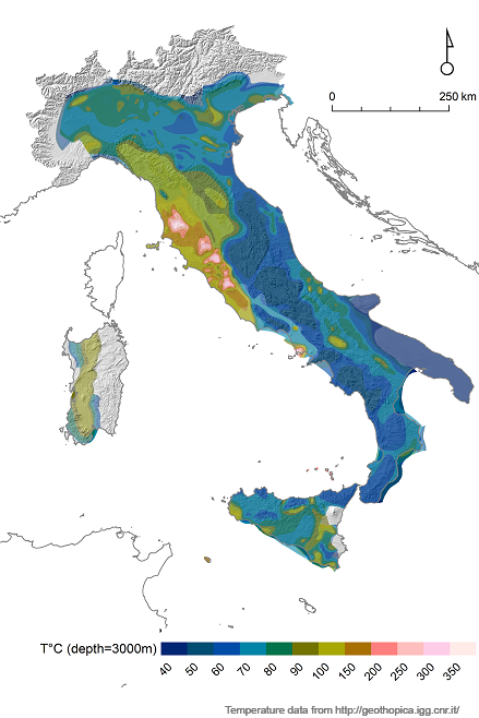
NEMESIS---NEar real-tiME results of Physical and StatIstical Seismology for earthquakes observations, modeling and forecasting.
- WP2 Statistical analyses, clustering and de-clustering of an earthquake catalog;
- WP3 Development and test validation of stochastic and physics-stochastic models for near-real time earthquake hazard in the short-term: multidisciplinary approach;
-WP4 System and web framework for data collection and visualization.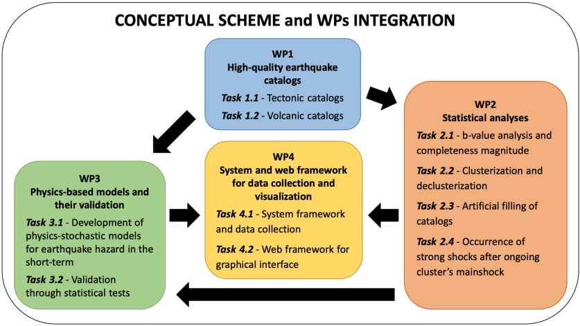
SMEEGOL - historical Sources, Mineral microanalysis, Experimental pEtrology and numerical modellinG to unravel the precursor phenomena Of voLcanic eruptions: the case of the neapolitan volcanoes.

UNITARY: Earthquake harbingers in the world from ground to space, with particular attention to Italian territory
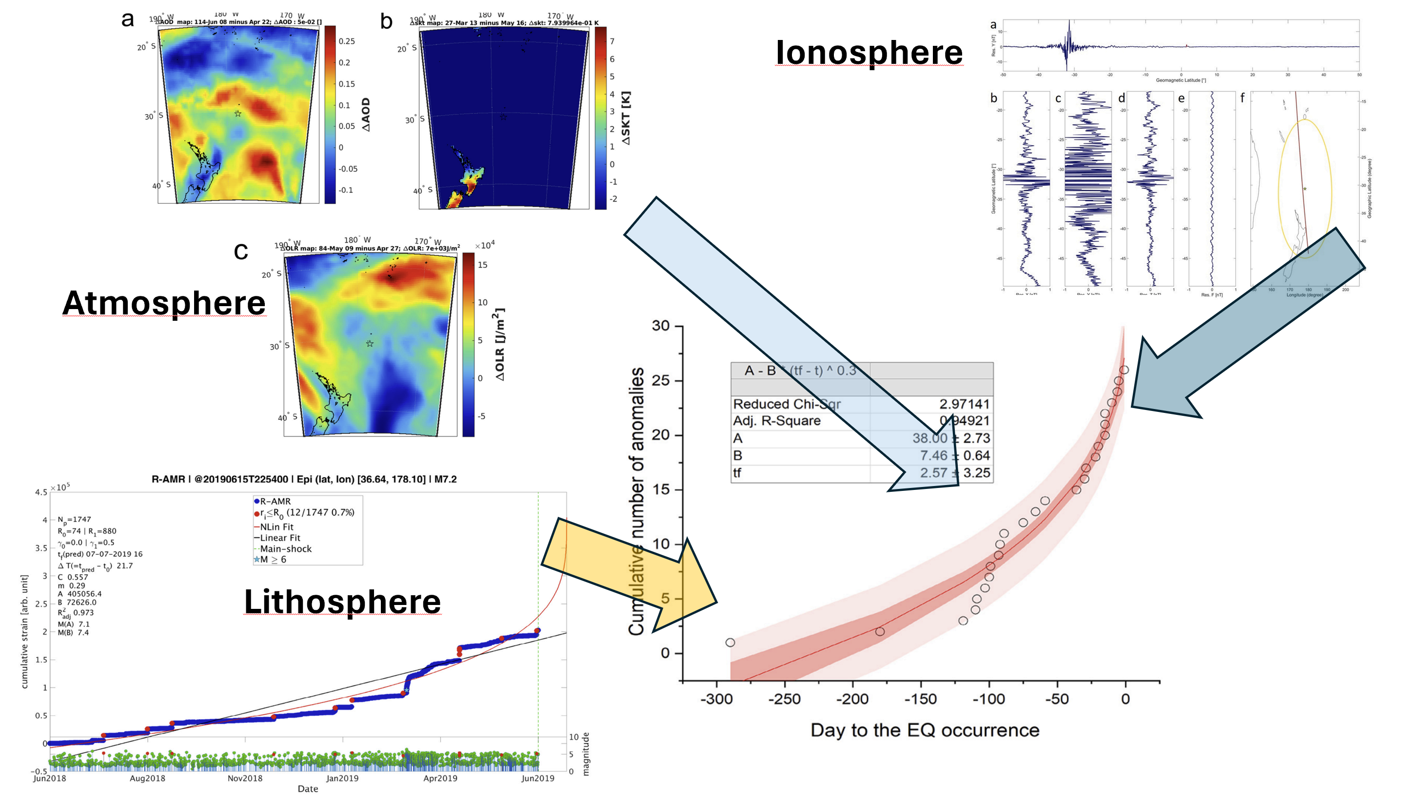 Figure 1. Multi-parameter and multi-layer approach to the 2019 M7.2 Kermadec Isl. Earthquake.
WUnderVul - Toward a Wider Understanding of Vulcano.
- WP2 - Hydrothermal system instabilities and phreatic events (Coord. L. Pappalardo), with 2 Tasks;
- WP3 - Development of Conceptual Models and link to monitoring (Coord. C. Federico), with 3 tasks;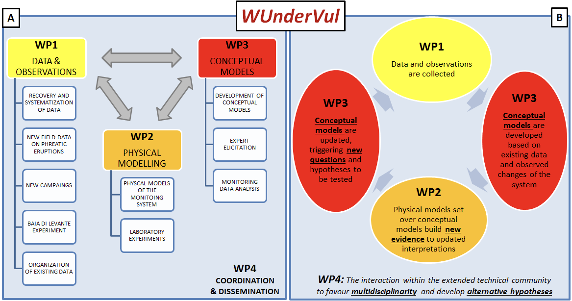
a) the shift of our society toward an efficient utilization of natural resources for a sustainable energy development,
b) a considerable reduction of the impact of natural disasters,
c) an increase of social and economic resilience, and d) a conscious planning of our future.

