The Project
InSEA Project: Initiatives in Supporting the consolidation and enhancement of the EMSO infrastructure and related Activities
The InSEA project ("Initiatives in Supporting the consolidation and enhancement of the EMSO research infrastructure consortium (ERIC) and related Activities") has the objective, as the full name of the project indicates, to consolidate and strengthen the infrastructures concerning the EMSO (“European Multidisciplinary Seafloor and water column Observatory”) ERIC (European Research Infrastructure Consortium) and all those technical-scientific activities related to it. In particular, the project is upgrading localized and distributed marine infrastructures, laboratories, observatories and spatial measurement activities in Southern Italian seas to support those activities of surveys in fixed time series points of observation of EMSO ERIC. The project is developing according to six implementation Objectives of Research (OR) that involve four National research Institutions: INGV, ISPRA, OGS and Anton Dohrn Zoological Station of Naples.
For more details, please see: De Santis et al., InSEA Project: Initiatives in Supporting the consolidation and enhancement of the EMSO infrastructure and related Activities, Frontiers in Marine Science, Volume 9 - 2022 | https://doi.org/10.3389/fmars.2022.846701 (from where most of the material of this website has been taken).
Generalities
The InSEA project has been funded by the Italian Ministry of University and Research for the years 2019-2022 (extended to 2023 because of the COVID Pandemic) as part of the Research and Innovation PON (“Programma Operativo Nazionale” - National Operational Program). The project involves four National research Institutions, i.e. INGV, ISPRA, OGS and Anton Dohrn Zoological Station of Naples.
According to the extended title of the InSEA project, its main goal is to launch initiatives to support the consolidation and enhancement of EMSO's infrastructures and its activities, which are positioned in the Italian territory and surrounding seas, with particular interest in the MS (from the Italian “Meno Sviluppate” meaning “Less Developed”) regions (Campania, Calabria, Puglia and Sicily) or in transition TR (Abruzzo and Molise).
The final scientific objective of the project is to improve the ability of the RI to record the geophysical and environmental processes of the marine environment in the seas of the MS / TR areas of the national territory, in order to monitor the state of the seas due to climatic changes or anthropogenic effects and natural hazards.
The project is developed according to six Objectives of Realization/Research (OR) that contribute to the achievement of the final objective (Figure 1). They consist in the upgrading of localized (OR1, OR2, OR6) and distributed (OR3, OR4) marine infrastructures, laboratories and observatories (OR4) and spatial measurement activities to support those activities of surveys in fixed time series points (OR7). INGV, OGS, ISPRA and SZN, partners in the JRU of EMSO-ERIC, participate in these activities. At the proposal stage, seven ORs were proposed, but six were finally accepted and funded (the OR5-Integrated Laboratories initially included in the proposal was not finally included in the project). However, we preferred to maintain the original numeration of the ORs.
The whole project, because of its complexity, requires both scientific and administrative coordinations (Figure 1), that act in synergy for solving all scientific (e.g., selection of the best equipment for each specific scientific goal) and administrative (e.g. purchase tenders, link with the funding Ministry, etc.) questions.
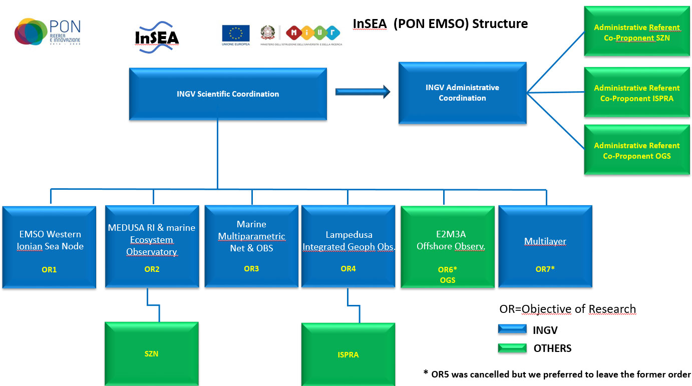
Figure 1. InSEA Project structure and Institutions’ roles. The Project for its complexity requires scientific and administrative coordination.
The close interconnection of the various OR and their products will represent a leap forward in the capabilities of the entire RI to acquire important scientific data to take advantage of advanced and excellence research in the fields of geophysics, geology, geochemistry, volcanology, oceanography and biology. Each OR covers an important aspect of the EMSO RI to be improved and extended (Figure 2).
Aim of the project
The InSEA project aims to increase at national level the network of marine observation and monitoring systems in accordance with EMSO-ERIC. The project will be aimed to reinforce already existing nodes of infrastructures integrated to a highly specialized and multidisciplinary laboratory network, dedicated to the study of a wide range of disciplines for the understanding of phenomena in the marine environment. The project may provide services (e.g. monitoring of sites of industrial interest in the marine environment, studies of human activities on marine biodiversity commissioned by public administrations) and propose highly specialized products (e.g. data from integrated sensor networks, or new sensors for specific applications).
InSEA is structured in different components with technological features that define the products that can be obtained and the services that can be delivered. In fact, it is composed of:
- Fixed observational infrastructures: a series of permanent structures that include measuring instruments distributed on the seabed and along the water column that continuously acquire time series of geophysical and oceanographic data; using electro-optical cables that extend on the bottom, the instruments are powered from the ground and send the acquired measurements in real time.
- Relocable systems: they are mobile structures composed of marine monitoring modules, mono- and multi-disciplinary, repositionable, to be used for specific experiments in areas of interest, boats with tools for periodic monitoring, mobile laboratories hosted in containers.
- Support infrastructures: they include equipment and instruments placed in ground laboratories and observatories to support marine operations and are necessary for the optimal management and maintenance of the wired network, as well as the management and use of relocatable infrastructures, and for the execution of research and specific services.
The project involves the enhancement of the infrastructures for research in the marine environment located in the MS Regions of Sicily, Calabria, Campania and Puglia and in the TR Regions of Abruzzo and Molise, for which the sea is a primary resource that creates development opportunities. The InSEA project is the Italian contribution to the consolidation in the above-mentioned regions of the European research infrastructure EMSO ERIC coordinated by Italy, which goes in synergy with other ERIC research infrastructures or in any case included in the latest Roadmap ESFRI published (2016).
The planned actions will be performed according to the following objectives:
1) to enhance the marine infrastructures and scientific and technological installations also on the ground to consolidate and expand the network for multidisciplinary monitoring of the coastal and deep marine environment and of the water column;
2) to establish of a mobile intervention system to be used for monitoring surveys in sites of strategic interest or in case of environmental emergencies;
3) to network all existing infrastructures and upgrade for real-time / near-real-time transmission, integrating the measurements of fixed and relocatable observing systems.
The number of researchers that are involved in the project was determined based on the number of researchers and technologists present in the various operating units involved in the project, including the co-proponents as well as the main proponent. Furthermore, the upgrading involves all the technical-scientific impact of the widespread infrastructure. In fact, given the relevance and excellence of the initiative, it is reasonable to expect that specialists from at least the member countries of ERIC, if not extra-European, require sharing infrastructure resources for new studies on an international scale.
The total space where the Project is established corresponds to the sum of the surfaces of the centers, laboratories and places used to host the equipment to be upgraded. The marine and submarine areas affected by the deployment of the infrastructure are not easy to estimate, however they include: South Adriatic, Gulfs of Naples and Pozzuoli, Lampedusa Island and surrounding sea, Portopalo, Catania Harbour, marine area of Eastern Sicily, off-shore Molise, offshore Puglia, offshore Calabria, offshore Southern Sicily (Sicily Channel).
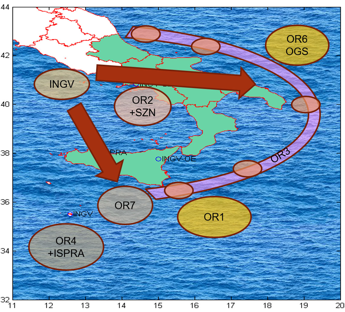
Figure 2. Scheme of the ORs with their main locations and interactions.
Units for Objective of Realization (OR)

OR1 Western Ionian EMSO Node
This OR intends to strengthen the EMSO infrastructure in Catania and Portopalo (Sicily) in order to guarantee scientific services or the continuous production of high-quality multidisciplinary data and access to them.
- Four new multidisciplinary platforms named CALIPSO, DIONE, TETI and DORIDE are being developed to be deployed at the two sites of Western Ionian Sea Facility. The platforms will host geophysical, oceanographical and environmental instruments and data acquisition will be acquired real time at the shore facilities at Catania and Capo Passero where a new EMSO Data Center will be installed.
- At the Catania Junction Box, the InSEA SMART (Scientific Monitoring And Reliable Telecommunications) cable will also be connected, with in situ pressure and seismic measurements to generate reliable tsunami height forecasts in Ionian Sea. Data coming from SMART cable will improve tsunami warnings based on land seismic data (Figure 3).
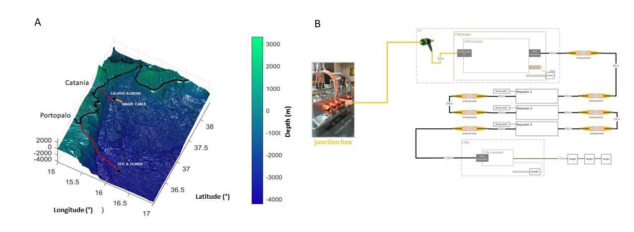
Figure 3. A) Western Ionian Sea map where the new four seafloor platforms and the SMART cable are indicated; B) Scheme of the SMART cable connected to the junction box offshore Catania site.
OR2- MEDUSA and Marine Ecosystem Observatory RIopen
Campi Flegrei is a volcanic caldera located west of Naples in the South of Italy that is continuously monitored by the INGV. The complex contains numerous phreatic tuff rings and pyroclastic cones and has been active for the past 39,000 years. This area is known for repeated cycles of significant slow uplift followed by subsidence.
With the aim to fill the information gap, previously based only on observations made through the dense multi-parametric network located on the mainland, in 2016 the MEDUSA infrastructure was born in order to monitor, in real time and in shallow water environment, the deformation of the submerged part of the Campi Flegrei’s caldera.
This OR will improve the capability of the geodetic/acoustic/oceanographic monitoring of the Pozzuoli – Campi Flegrei and Naples Gulfs.
For the site in the Gulf of Pozzuoli – Campi Flegrei (INGV)
- Assets for upgrading the MEDUSA (Multi-parametric Elastic-beacon Devices and Underwater Sensors Acquisition system) out of water infrastructure (EMERGED-Top)
- Resources for expansion and upgrading of the CUMAS multi-parametric submarine module, (EMERGED-Bottom).
MEDUSA is a multi-parametric permanent marine monitoring and research infrastructure based on instrumented geodetic buoys operating in the Gulf of Pozzuoli (close to Naples, Italy) within the local surveillance system of the Campi Flegrei volcanic caldera (Figure 4).
MEDUSA is a complex research infrastructure consisting of four buoys equipped with multi-parametric submarine observatories (wired with as many surface buoys), consisting of geophysical and oceanographic instrumentation, and continuous real time data acquisition/transmission to the Monitoring Center of INGV in Naples (Vesuvius Observatory), where data are integrated to those acquired by the land networks.
The four buoys, of the elastic-beacon type, are positioned on variable depths less than 100m at a distance of about one mile from the coastline. The submarine modules are laid on the sea-bottom and equipped with scientific and control instruments. A geodetic GPS receiver is installed on each turret to measure ground movements at the seabed (Chierici et al. 2016).
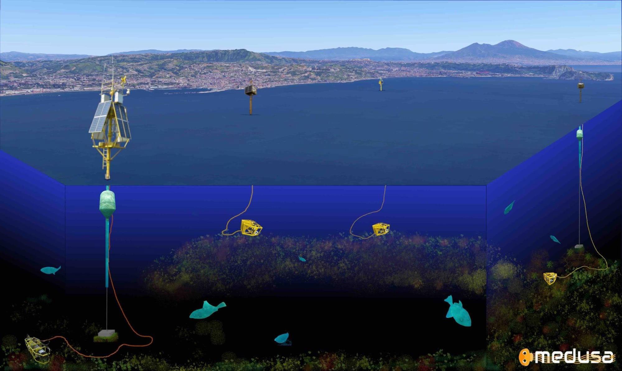
Figure 4. A mixed image-representation view of the MEDUSA's marine research and monitoring infrastructure (Campi Flegrei volcanic area).
MEDUSA is a sophisticated infrastructure for monitoring at sea the volcanic activity of Campi Flegrei, realized as completion of the geophysical instrumentation networks existing on the mainland and managed by the INGV, Vesuvius Observatory (De Martino et al. 2020; Iannaccone et al. 2020). With the economic resources deriving from the InSEA project, the external mechanical parts of each buoy were redesigned, and the external instrumental park and the submarine observatory of one of them were upgraded (Figures 5 and 6).
MEDUSA mainly monitors the local seismicity and the seafloor ground movements in the volcanic area of Campi Flegrei’s caldera with geophysical and oceanographic sensors.
The MEDUSA infrastructure extends the geophysical monitoring system of Campi Flegrei, in the Gulf of Pozzuoli. Through the use of this infrastructure it is possible to improve the definition of the area of deformation of the area by means of continuous measurements of ground movements on the seafloor (geodetic measurements at sea by analyzing the vertical and horizontal components of the GPS receiver, in conjunction with data analysis of precision pressure sensors installed on the seafloor). More information about MEDUSA infrastructure can be found on the web portal http://portale.ov.ingv./medusa.
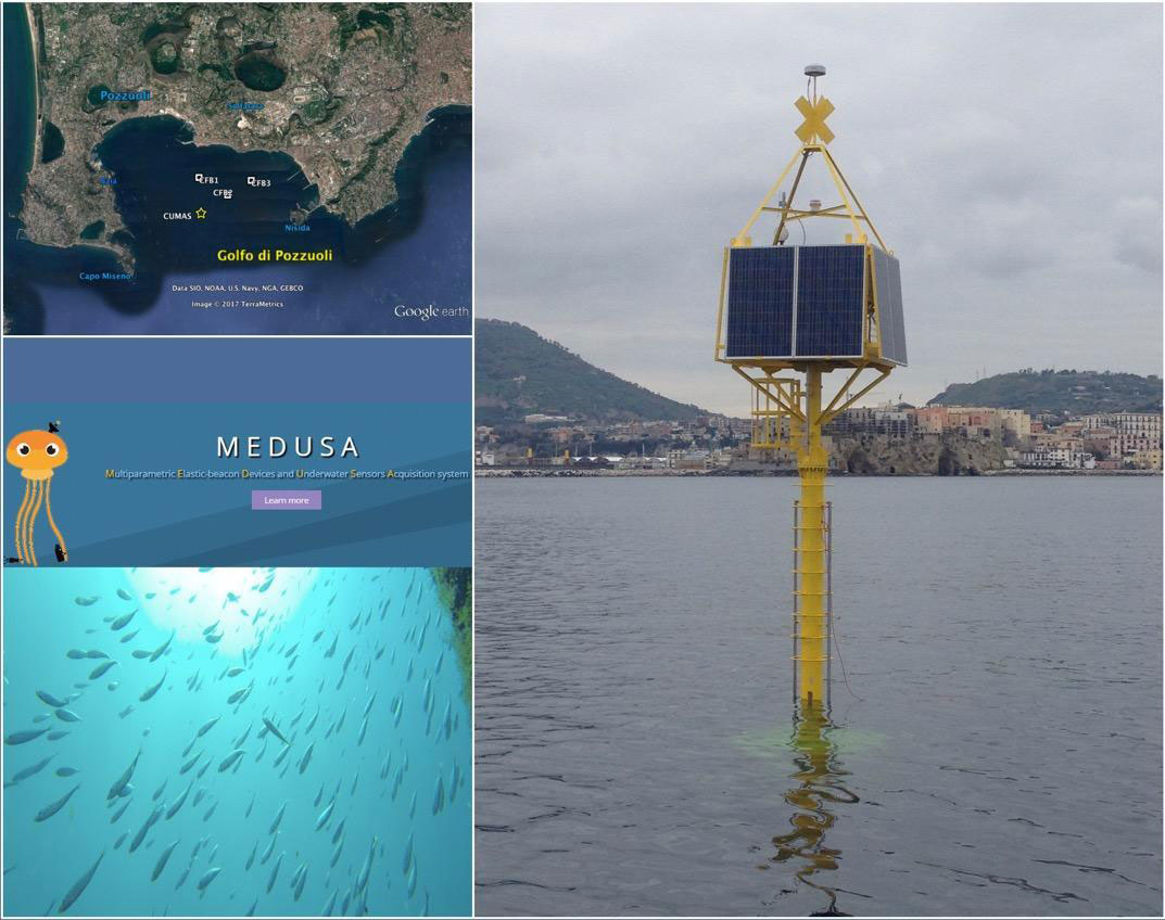
Figure 5. From top-left: the geographical volcanic area where MEDUSA lives; the emerging part of a buoy; an image provided by a submerged HD-camera.
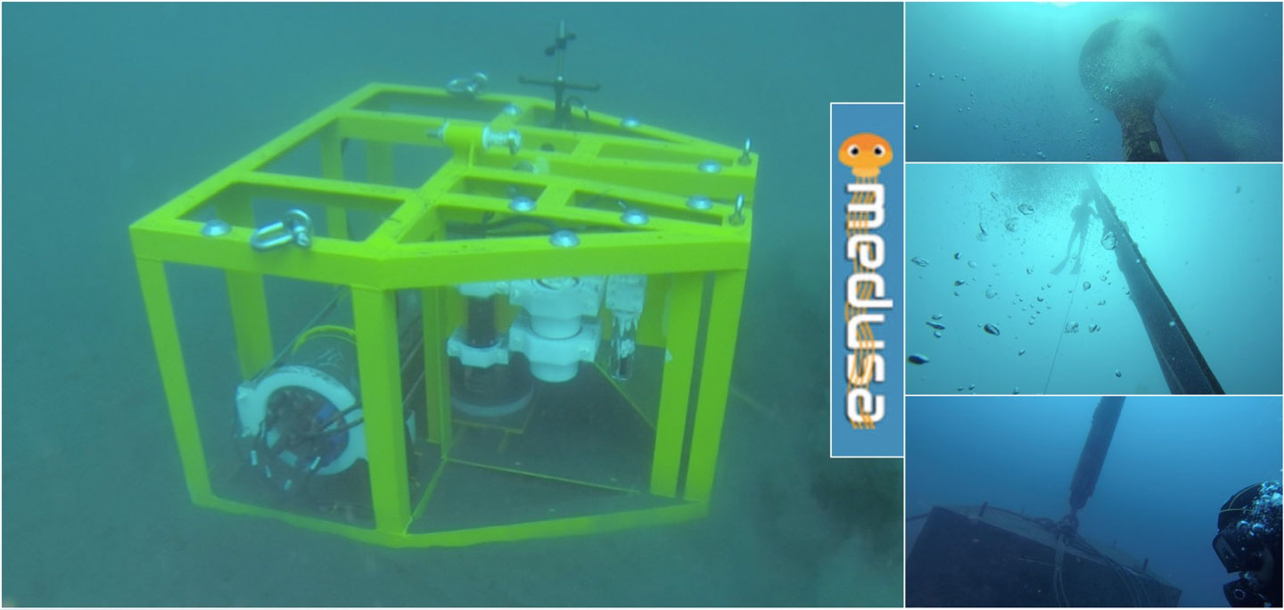
Figure 6. From left to right, top to down: the seafloor multi-instrumented observatory; the underwater view of the floating from the bottom by an UHD submerged camera; a diving operator who performs an inspection on the electro-mechanical cable that ensures the connection of the seafloor observatory to the top of buoy (for the power-supply, Ethernet link and the GPS communication for the time-marking of the data acquired); the buoy ballast on the seabed (see also Xie et al. 2019).
For the site in the Gulf of Naples (SZN) (Figure 7).
- Mooring not wired in stand-alone mode
- Infrastructure at the bottom (seabed platform) connected to a surface buoy
The infrastructure will have the purpose of monitoring geophysical and oceanographic processes in the Gulf of Naples that affect biodiversity near the bottom and in the water column.
The Gulf of Naples is a particularly interesting area from the volcanological (Campi Flegrei), oceanographic and bio-ecological points of view, due to the presence of the Dohrn Canyon, site of upwelling processes.
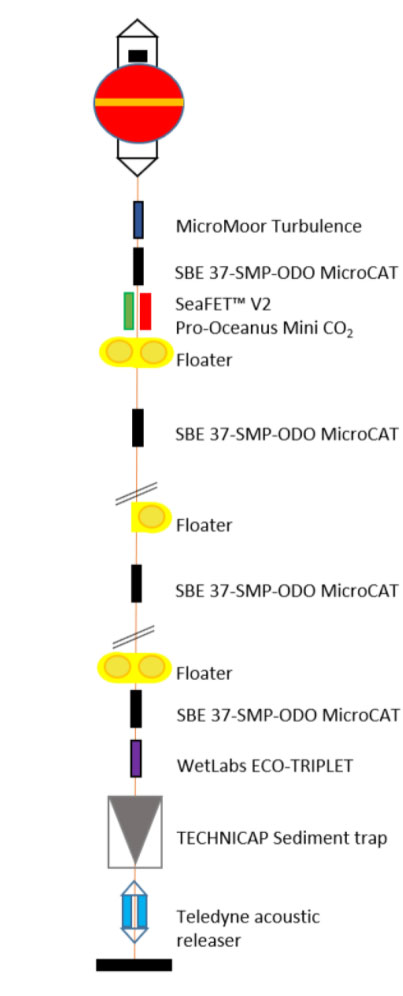
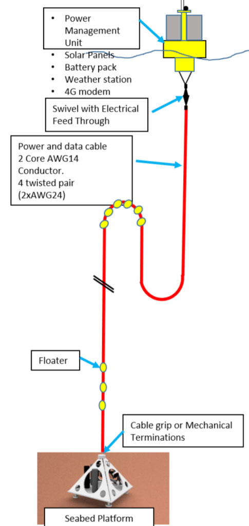
Figure 7. Left: Naples Ecological Research-Fixed seabed Observatory (NEREA-Fix); Right: Seabed platform connected with a surface buoy.
OR3- Marine Multiparameter Network and OBS
This OR intends to i) increase the equipment for seafloor seismic monitoring (Ocean‑Bottom seismometers: OBS) and ii) extend the seismic and geophysical network to the Adriatic and Ionian Sea, by deploying new monitoring nodes within the safety areas of 5 oil platforms. The final aim will be to extend EMSO multi-parameter monitoring activities in MS and TR areas, with relocatable (BB-OBS) and fixed systems. The following resources and pieces of equipment will be acquired:
- 7 submarine multi-parameter modules (MSM) with trawl resistant shape, 5 of which will be installed and 2 will be used as spare units; the latter will allow to replace the operating ones at scheduled deadlines, for cleaning and calibrating the sensors, in order to guarantee continuity of operation and data flow;
- 8 Broad Band Ocean Bottom Seismometers (BB-OBS / BB-OBS TR) with trawl resistant shape;
- Laboratory equipment for maintenance and remote control of the marine equipment.
Each MSM includes a submarine module (deployed on the seafloor about 200-300 m away from the platform) connected by an electromechanical cable to a surface module on the platform (Figure 8); the latter monitors the marine instruments and transfers the data collected from the seafloor to the monitoring centres at INGV.
The submarine module will have the following multi-parameter instrumentation:
- VBB Ocean Bottom Seismometer (120 sec - 100 Hz)
- Multiparameter Probe (O2 and Turbidity)
- Paroscientific Absolute pressure sensor
- Hydrophone
- CTD
- ADCP
The total weight of the submarine module in seawater will be about 160 kg, sufficient to make the module penetrate several centimetres in the seabed to obtain a good coupling of the seismic sensor with the bottom and to guarantee a good resistance to trawling.
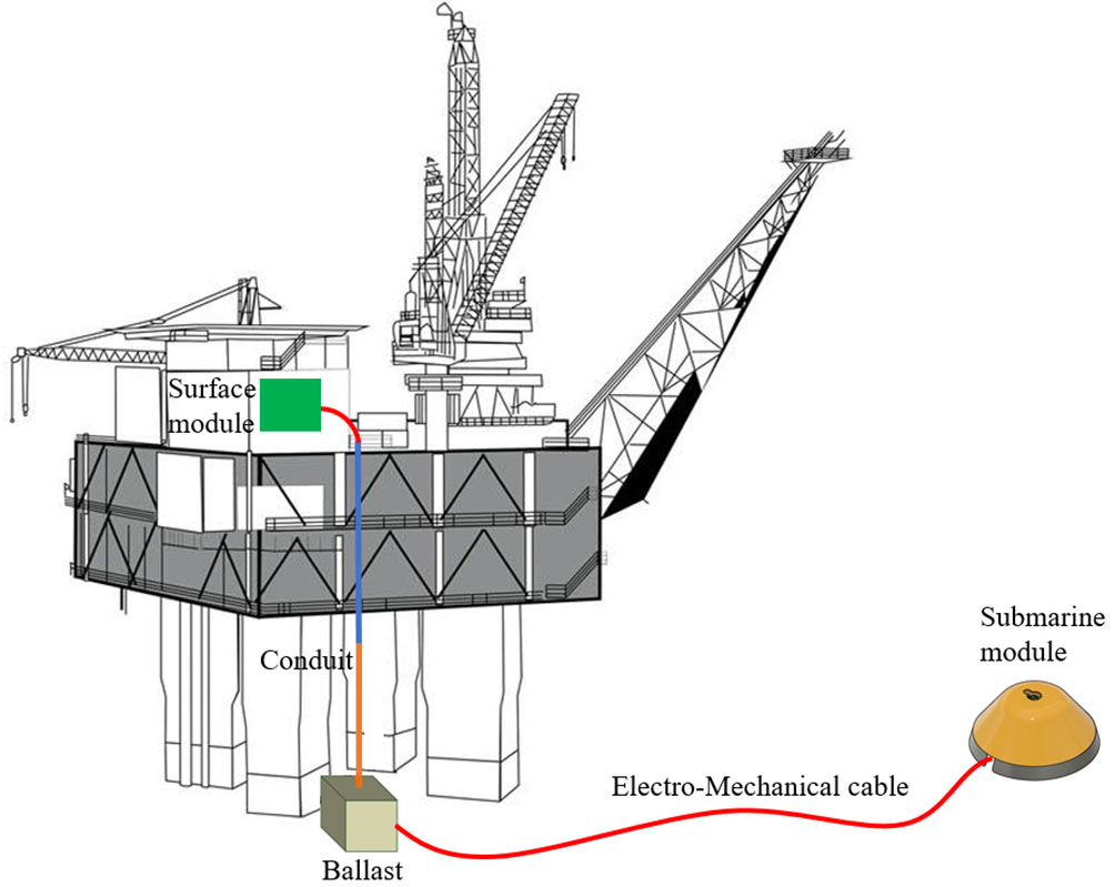
Figure 8. Schematic of an oil platform instrumented with MSM.
OR4 - Lampedusa Integrated Geophysical Observatory
This OR will perform the following activities: i) Enhancement of the instruments in use at Lampedusa Island Observatory (INGV; Figure 9); ii) and acquisition of equipment for improving the instrumentation of M/V Lighea and Perseo ROV (ISPRA; Figure 10).
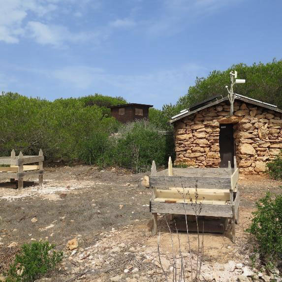
Figure 9. Lampedusa Island Geophysical Observatory. The stone hut, due to its non-magnetic properties, is dedicated to absolute magnetic measurements, while the two fences protect the buried geophysical sensors.
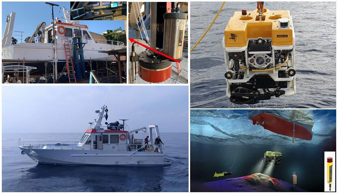
Figure 10. M/V Lighea equipped with Kongsberg EM 2040 Compact Multibeam Echosounder Systems (MBES). ROV Perseo equipped with Kongsberg PAP 200 series USBL systems.
This OR will enhance the Integrated Geophysical Observatory of Lampedusa for the improvement of the calibrations of marine magnetic measurements in the sites offshore Catania and Portopalo, and the use of ionospheric radio transmissions for both ship and buoy operations. The completed and integrated stations will also be the key points of integrated geophysical observation at the southernmost part of Europe (Di Mauro et al, 2021). It will then also reinforce the instrumental equipment of the M / V Lighea and the ROV Perseo (ISPRA).
OR6-E2M3A offshore observatory
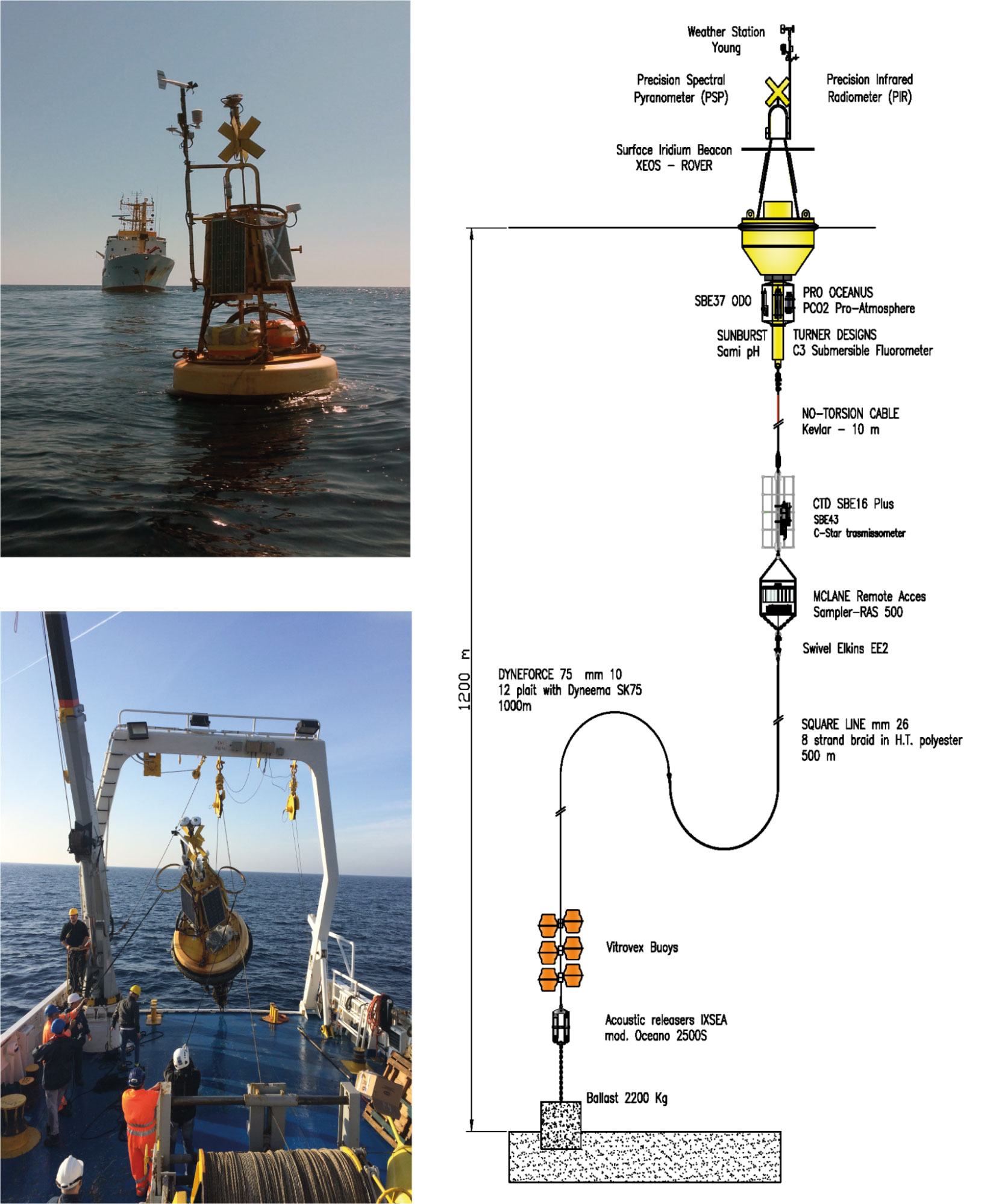
The main objective of this OR is the strengthening and development of the E2M3A offshore observatory, (Eastern Mediterranean 2 Multidisciplinary Mooring Array) as a contribution to the EMSO-ERIC infrastructure (Figure 11). The E2M3A observatory is part of the Southern Adriatic Regional facility of EMSO-ERIC (Cardin et al. 2016). Oceanographically, it is positioned in the centre of the cyclonic gyre where deep convection processes take place, involving both the atmosphere and the ocean dynamics forming new dense and oxygenated waters. The Southern Adriatic Interdisciplinary Laboratory for Oceanographic Research is particularly devoted towards studies for characterizing the long-term changes of the Adriatic Sea in response to local climatic forcing (Querin et al. 2016).
By implementing sensors, the OR will improve the quality and efficiency of transmission and display in near real-time and delayed observations of key (essential) variables relevant for monitoring environmental processes, natural hazards, climate change, and offshore marine ecosystems. All the information will be useful for navigation, fishing, and tourism information on water quality, with great contributions for monitoring climate change.
In particular, it will acquire the following equipment.
- Buoy hull and acoustic releases for structural purposes of E2M3A and safety
- Meteorological station
- Instrumentation for the increase and diversification of biogeochemical measurements
- Acoustic profilers for spot current measurements along the water column
{slider title="OR7 Multilayer" open="false" class="icon"}
This OR will perform a distributed enhancement of the whole southern Italy infrastructure at different observational levels (from bottom to up, i.e. from submarine AUV to aerial vehicles). It will give particular attention to potential (magnetic and gravity) field observations. Therefore, in short words, it will enhance the RI in the sites offshore Catania and Portopalo (Sicily) from aircraft and marine AUV.
Equipment that will be acquired is (see also Figure 12):
- Innovative systems for the observation of geophysical / environmental parameters airborne applications
- Completion / integration provision for the AUV.
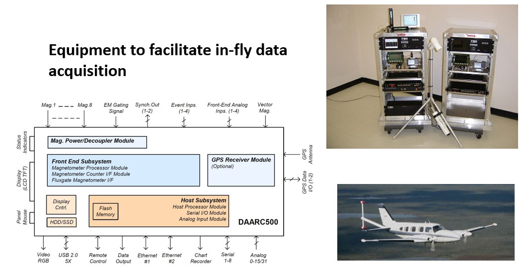
Figure 12. Equipment to facilitate in-fly data acquisition for potential field studies: on the left, the scheme of the various component of the system (DAARC 500); on the right top, the system under calibration in the laboratory; on the right bottom, the airplane used for the scientific survey in operational configuration.
The implementation scenarios are diversified but integrated with each other. Tenders and acquisitions will be carried out for the acquisition of assets, their validation and implementation. Many of the assets will be installed at the location sites, that is, on seabed or in laboratories functional to the EMSO research activities.
Particular attention in modulating the tenders and purchases will be essential to better match the various subsequent activities, giving priority to those at sea, due to the obvious difficulties of these operations. The experience and skills of the involved operational units, however, put the possible level of criticality to the minimum.
Post-project scenario
 At the end of the InSEA three-year project, the RI EMSO will enrich through the OR1, the instrumental equipment of the submarine infrastructures in Catania and Portopalo sites, together with the deposition of a SMART cable, as a single pilot test for the monitoring of the climatic parameters and of possible tsunamic events. The MEDUSA network for the research in marine environment in the Gulf of Pozzuoli will be enhanced by updating the surface area and renewing one of the seabed sites (CUMAS) according to the provisions of OR2. In the same context, the monitoring area of the geophysical and oceanographic processes that affect the biodiversity of the megafauna near the bottom and in the water column in the Gulf of Naples will also be extended. The OR3 will allow the installation of a multiparameter observation network at the hydrocarbon extraction platforms located in the MS and TR areas, expanding and extending at sea the effectiveness of the ground network, geophysics in general, and seismic in particular. The same OR will increase the number of releasable broadband OBS systems useful for geophysical research surveys in Italian seas, in particular at Western Ionian. Another important aspect, produced by OR4, will be linked to the upgrading of the Lampedusa integrated geophysical Observatory, in its geomagnetic and ionospheric functions, with an expansion of the repositionable OBM modules set that will extend the knowledge of the relations of magnetic, ionospheric and marine chemical-physical parameters with natural phenomena such as earthquakes and volcanic activity. Consequently, the magnetic research capacity on seabeds of precursors of tsunamis and seismic events increases. The same OR will enrich the instruments of the M / V Lighea and the ISPRA ROV. The OR6 enhances the site on the seabed in the southern Adriatic with innovative equipment, multiplying the quality of the observational characteristics. The OR7 will make available instrumental equipment for aircraft and AUV, very useful to expand the observational possibilities of submarine sites by extending the knowledge of the physical-chemical parameters of the marine environment into the spatial domain.
Expected results
 The consolidation and enhancement of RI EMSO on the basis of the activities guaranteed with the purchase of assets within InSEA will make the observational submarine network more efficient, placing it at the cutting-edge level in the European scenario. Furthermore, it will improve the geophysical, oceanographic and climate knowledge of the planet, thanks to continuous and timely observation over long time series at submarine observatories and others. EMSO pursues the long-term objective to be part of the upcoming European Ocean Observing System (EOOS). The latter is expected to integrate multiple platforms and data systems, comprising other ERICs, to achieve the first sustained, standardized and permanent marine observatory network of Europe. InSEA, together with other initiatives of EMSO, i.e. EMSO-Link (http://emso.eu/emso-link/) will facilitate the coordination of EMSO infrastructure as well as reinforce and expand the EMSO ERIC membership to optimize the inclusion of the whole European Marine technology and research institutions. The synergy between INGV and the other research institutes of InSEA (specifically, ISPRA, OGS and SZN) will enable us to achieve excellence in the field of marine observations, by diversifying its effects into new application domains, such as the mitigation of natural and climatic risks , safety in the seas, the interoperability of different instruments placed in sites of scientific and productive interest. The band of multidisciplinary skills and the integration of geophysical, geological, volcanological, oceanographic, climatological and biological knowledge are aspects that ensure the full technical / scientific ability to achieve borderline knowledge.
Important efforts will be given to the offered data and services. Data and metadata will be in accordance with those of INGV and other public research institutes (e.g. seismic data as EIDA- European Integrated Data Archive- format, magnetic data as INTERMAGNET standard). There will be complete possibility to virtual access to some validated data and metadata (e.g. seismic data from marine platforms and smart cable; magnetic data from Lampedusa Geophysical Observatory; geophysical and environmental data from Naples, Pozzuoli and E2M3A) with complete integration with the MOIST (Multidisciplinary Oceanic Information System) platform which is a data management system for multi-paramteric observatories focused on standards, open accessibility and web services (www.moist.it). During the time of the project development and its consequential time of RI maintenance, some possible experiments could be developed under request. Young personnel (operators and scientists) dedicated to parts of the RI will be trained with specific practical and theoretical courses provided by professionally mature scientists.
The InSEA infrastructure, being fully included in EMSO ERIC RI, would take advantage of the support of JRU e/o of EMSO ERIC in the following areas:
- Greater availability of data on the web (data retrieval and communications);
- Technical Support to have data more adherent to FAIR guiding principles (Find-ability, Accessibility, Interoperability, and Reusability);
- Support for logistics in the maintenance;
- Training Courses organization.
The expected reinforcement in the InSEA project of the infrastructures that constitute integral parts of EMSO ERIC, represents a unique opportunity to create the conditions to attract international scientific excellence in laboratories and distributed nodes. The adoption of an Open Access policy, adopted at European level, implies open access to the international scientific community, and to a wider representation of the public and private sectors.
This will produce a multiplier effect that will reward the investment from different points of view. The return is in fact potentially on scientific knowledge, on the economy, on the ability to protect the environment and to mitigate the effects of environmental disasters. Furthermore, the project contributes to the goals of EMSO ERIC, such as the promotion of a sustainable use of the seas and the conservation of marine ecosystems. These objectives are in line with the indications of the European Commission, which in turn are implemented by ESFRI for research infrastructures, e.g. the Marine Strategy Framework Directive, the Maritime Spatial Planning Directive, the Blue Growth Strategy and the G7 Future of the Sea and Ocean Initiative.
In summary, InSEA has a strategic relevance because:
- It will contribute to attracting high quality human capital.
- It will help to create a new market for local companies, producing high level jobs.
- It will be the first step towards the creation of an instrument (to be used by local authorities) to control the marine environment, having the potential to monitor the quality of water, marine flora and fauna.
- It will provide a tool to support the understanding of disastrous natural phenomena in sensitive areas: InSEA will be able to check new and more effective methods to develop early warning instruments of environmental risk, such as that caused by tsunamis, or biological phenomena, such as the proliferation of toxic algae.
Discussion and Conclusions
The InSEA project intends to consolidate and enhance the definitive sites at Western Ionian Sea Facility of the EMSO infrastructure or the test-sites, the latter developed in the PON EMSO-MedIT project, as part of similar initiatives on European scale carried out by the other European EMSO-ERIC partners for the purpose of reinforcing of the EMSO sites of which they are responsible. These activities are based on regional, national and European financial support (infrastructural funds). Therefore, the InSEA project will place the Italian country aligned with the other European participants in EMSO ERIC.
As already underlined, EMSO ERIC is usefully included in the ESFRI Landmark (Womersley et al., 2016), that is to say, EMSO is among the RI considered successful for ESFRI. Regarding our country, the launch of the JRU EMSO-Italia is certainly the vehicle to reinforce the Italian presence and its excellence, highlighting the scientific and technological skills of our marine community compared to other countries.
All this reinforces the presence and the Italian role in the field of scientific research and industrial development, with well established or emerging rapidly possibilities growing in recent years.
Next, we define a classification of potential users of services and technologies:
- national and international scientific community;
- industrial sectors directly related to the use of the sea as a resource, in particular:
- oil & gas
- renewable energy;
- public administrations dedicated to monitoring the marine environment and related risks,
- international organizations dedicated to the analysis and monitoring of climate and environmental risks (for example UNEP, etc.)
- port authorities, as regards the part related to coastal monitoring;
- tourism, which is highly dependent on the quality of coastal waters.
The reinforcement given by the InSEA project of the infrastructures present in the national territory makes the participation of our community unique compared to the other countries participating in the EMSO ERIC infrastructure. This also presents characteristics of excellence throughout the national territory, because it supposes a strong driving force for the development of both highly professional figures and industrial-related ones, increasing the competitiveness of our companies (SMI or large companies).
Once the potential users have been defined, we can classify a series of services that the InSEA project can deliver using the enhanced infrastructures, in particular:
- integrated monitoring of the marine environment in real time;
- consultancy for environmental analysis at sea and feasibility studies;
- studies of the effects on biodiversity of productive activities that require the exploitation of the sea;
- development of specific sensors for marine applications;
- development of data acquisition and processing systems.
For example, these elements may refer to relevant research activities that could be initiated thanks to the proposed enhancement. Otherwise, this scientific knowledge could not be obtained and the development of cutting-edge technologies could be impeded / delayed.
InSEA project will firmly establish the basis for a better knowledge of the Mediterranean Sea and its whole complex system, contributing to a deeper knowledge of the central role of oceans and how the entire world is working and developing, with the intriguing interconnection among all its parts (Lenton 2016).
References
Cardin V. et al. (2016). A multidisciplinary observing system to understand oceanographic processes in the open Adriatic Sea. 41st CIESM Congress, Kiel.
Chierici, F., G. Iannaccone, L. Pignagnoli, S. Guardato, M. Locritani, D. Embriaco, G. P. Donnarumma, M. Rodgers, R. Malservisi, and L. Beranzoli (2016), A new method to assess long-term sea-bottom vertical displacement in shallow water using a bottom pressure sensor: Application to Campi Flegrei, Southern Italy, J. Geophys. Res. Solid Earth, 121, 7775–7789, doi:10.1002/ 2016JB013459.
De Martino P., Guardato S., Donnarumma G.P., Dolce M., Trombetti T., Chierici F., Macedonio G., Beranzoli L. and Iannaccone G. (2020). Four years of continuous seafloor displacement measurements in the Campi Flegrei caldera. Frontiers in Earth Science, 8:615178. | doi:10.3389/feart.2020.615178
Di Mauro D., De Santis A., Tozzi R. (2006). The magnetometers and the geomagnetic data from GEOSTAR, a deep seafloor multidisciplinary observatory, Boll. Geof. Teor. Appl., vol.47, n.1-2, 105-114.
Di Mauro, D., Regi, M., Lepidi, S., Del Corpo, A., Dominici, G., Bagiacchi, P., Benedetti, G., Cafarella, L. (2021). Geomagnetic Activity at Lampedusa Island: Characterization and Comparison with the Other Italian Observatories, Also in Response to Space Weather Events. Remote Sens., 13, 3111. https://doi.org/10.3390/rs13163111
Iannaccone, G., Guardato, S., Donnarumma, G. P., De Martino, P., Dolce, M., Macedonio, G., Chierici F., Beranzoli, L. (2018). Measurement of seafloor deformation in the marine sector of the Campi Flegrei caldera (Italy). Journal of Geophysical Research, 123 | doi:10.1002/2017JB014852
Lenton T. (2016). Earth System Science: a very short introduction, Oxford Univ. Press.
Querin, S., Bensi, M., Cardin, V., Solidoro, C., Bacer, S., Mariotti, L., Stel, F. and Malačič, V. (2016). Saw-tooth modulation of the deep water thermohaline properties in the southern Adriatic Sea. J. Geophys. Res.Oceans, 121, doi:10.1002/2015JC011522.
Womersley J. et al., Strategy Report on Research Infrastructures, Science and Technology Facilities Council, 210 pp., 2016.
Xie, S., Law, J., Russell, R., Dixon, T. H., Lembke, C., Malservisi, R., et al (2019). Seafloor geodesy in shallow water with GPS on an anchored spar buoy. Journal of Geophysical Research: Solid Earth, 124, 12,116–12,140. https://doi.org/ 10.1029/2019JB018242
InSEA Team
Scientific Responsible: Angelo De Santis (1),
Administrative Coordinator: Massimo Chiappini(1),
OR1 Resp.: Giuditta Marinaro(1)
OR2 Resp.: Sergio Guardato (1)
OR2 SZN Resp.: Fabio Conversano (2)
OR3 Resp.: Giuseppe D’Anna (1)
OR4 Resp.: Domenico Di Mauro (1)
OR6 Resp.: Vanessa Cardin (3)
OR7 Resp.: Roberto Carluccio (1)
Other Active Components:
Sante Francesco Rende (4), Raffaele Giordano (1), Lorenzo Rossi (4), Francesco Simeone (1), Emanuele Giacomozzi (1) , Gioacchino Fertitta (1), Antonio Costanza (1), Rosario Riccio (1), Giuseppe Siena (3) and Giuseppe Civitarese (3)
Affiliations
(1) Istituto Nazionale di Geofisica e Vulcanologia (INGV), Italy
(2) Stazione Zoologica Anton Dohrn di Napoli (SZN), Italy
(3) Istituto Nazionale di Oceanografia e di Geofisica Sperimentale (OGS), Italy
(4) Istituto Superiore per la Protezione e la Ricerca Ambientale (ISPRA), Italy


Il sito web è stato realizzato con il cofinanziamento dell’Unione europea, PON Ricerca e Innovazione 2014-2020 (“The website was created with the co-financing of the European Union, PON Research and Innovation 2014-2020.”) http://www.ponricerca.gov.it/pon-ricerca/programme/.
Uffici responsabili della pubblicazione (Offices responsible for publication): Istituto Nazionale di Geofisica e Vulcanologia, Via di Vigna Murata, 605, 00143 Roma, Italy.