
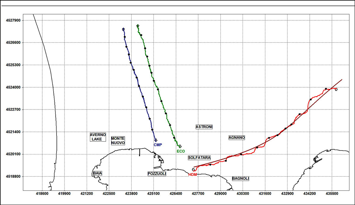
Tilt vectors at the three tiltmeters CMP (blue), ECO (green) and HDM (red).The curves are the cumulative tilt variation (hodograph) recorded in 2021. The black dots superimposed mark the monthly tilt. The tilt increase on the NS component is northward down with respect to the site, the tilt increase on the EW component is eastward down. Grid spacing tilt variation of 10 μradians.
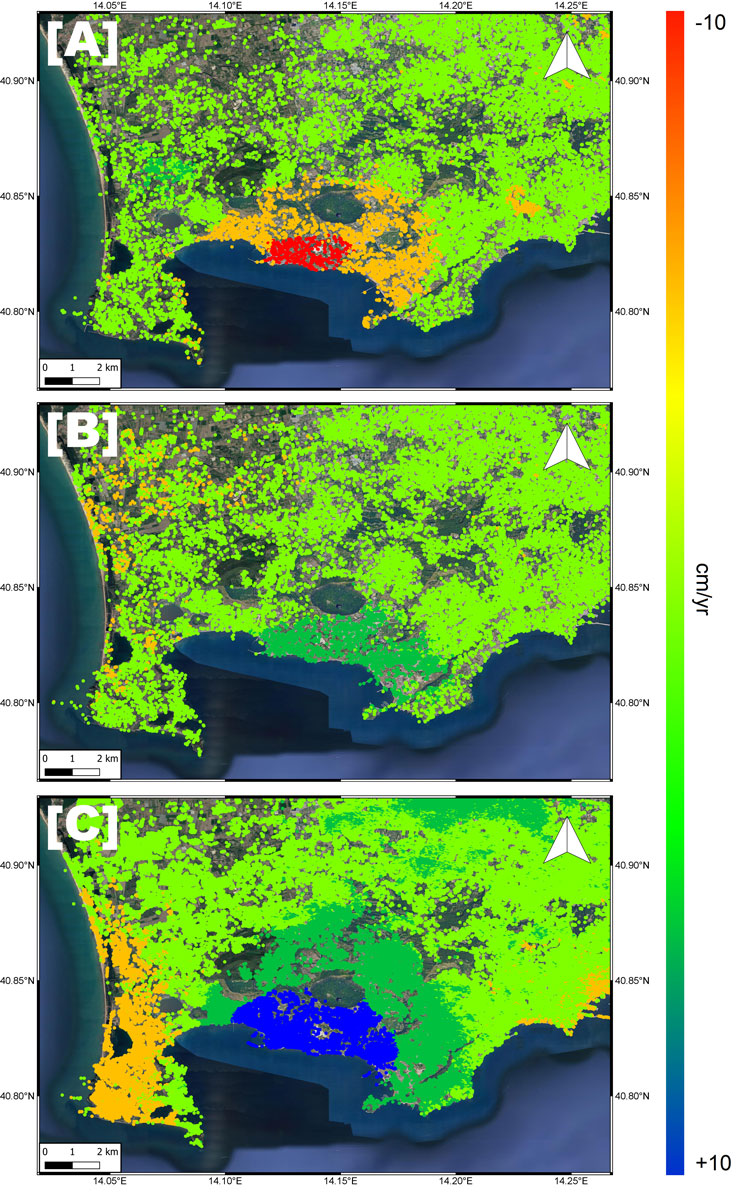
Campi Flegrei ground velocity maps retrieved by InSAR analysis from several SAR missions. [A] ERS (1992-2002), [B] Envisat (2003-2010) and [C] Cosmo-SkyMed (2011-2020) SAR images.
Objectives
WP 4 aims at addressing the long-term and short-term deformation styles at Campi Flegrei, considering most of the available geodetic data and analyzing new data. The observed deformation is interpreted by inverse modelling and by building advanced models of the plumbing system. The recent activity of uplift/deflation, detected by several modern geodetic techniques, will be considered and related to the study of the historical deformations at Campi Flegrei. Also, a new dataset of archeological elevation changes of Campi Flegrei is analyzed and modelled, disclosing many details on the past activity at Campi Flegrei. The WP is organized with two tasks, task 4.1 that collects the geodetic and gravimetric data, with task 4.2 mostly devoted to data interpretation and modelling.
Task 4.1 Geodetic and gravimetric data analysis
An unprecedented set of geodetic data at Campi Flegrei from leveling, tilt, InSAR (Interferometric Synthetic Aperture Radar) techniques, and seafloor measurements will be analyzed and collected.
In particular
- the long-term archive of leveling data along the Pozzuoli coast is integrated with geological and archaeological observations. Archeological archive data since 35 b.C. is analyzed for the first time.
- The database is integrated with data from the tiltmeter network, presently including 10 stations, available since 1998.
- The capability of InSAR data is fully exploited in the project to create displacement maps and time series from the whole C-band Envisat data archive (2002-2010) and Sentinel data (since 2014) from the European Space Agency, along with ASI’s (Agenzia Spaziale Italiana) X-band Cosmo-SkyMed satellite data since 2010.
- The seafloor measurements produced by the marine infrastructure MEDUSA are included in the WP, and given the large submerged portion of the CF caldera, these data will significantly improve the knowledge of the ground deformations
- Possibly, archive gravimetric data will be taken into account to characterize the hydrothermal/magmatic nature of the past and present unrests.
Task 4.2 Long-term and short term deformation history and characterization of eruptive and unrest volcanic sources
The objective of this task is analyzing short-term and long-term deformation styles, and their relationship with the volcanic activity and plumbing system at Campi Flegrei. Inverse modelling is performed to interpret the available geodetic datases to retrieve the deformation system at Campi Flegrei. The large amount of data available is considered with different time windows. In particular, one objective is to study the past behaviour of Campi Flegrei by modelling the archeological data since 35 BC. Also, modern geodetic data from the local networks are modelled with a similar approach to understand the volcanic activity through centuries at Campi Flegrei. Numerical models of the volcanic source and plumbing system are developed based on the updated knowledge of the volcanic activity and including realistic features of the Campi Flegrei volcanic system. The models account for new insights derived from volcanological/petrological (WP1), geochemical (WP2) and seismological (WP3) studies. The causes for the subsidence/uplift and gravimetric variations are addressed considering the effect of several factors which may act along with magmatic activity at depth, such as - for instance - temperature and pressure variations within the hydrothermal system, presence of elastic discontinuities and inelastic rheology, and the action of structural discontinuities such as the faults related to both caldera collapse and resurgence of its floor. The models are applied both to the current unrest of the Campi Flegrei, and to characterize the past long-term pre-eruptive phases. In collaboration with task 1.2, initial stress scenarios will be produced for dyke propagation simulations.