WP1.2 - Seismic Structure
Participants: Pasquale De Gori, Francesca Di Luccio, Luigi Improta, Davide Piccinini, Patricia Persaud, Claudia Piromallo, Matteo Scarponi, Rosaria Tondi, Luisa Valoroso, Guido Ventura
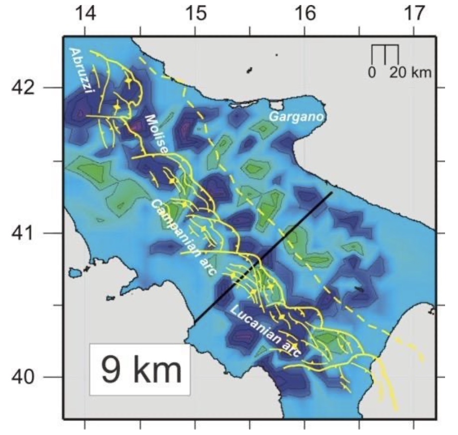
To understand the relationship of anomalous CO2 flux of deep (mantle) origin and seismicity occurrence, a comprehensive knowledge of the crustal structure at high resolution is required. Hence, the main goal of WP1.2 is to obtain high-resolution 3D images from the shallow crust to the upper mantle of the Southern Apennines, from local (fault) to regional scale, to constrain the heterogeneous subsurface features in terms of seismic velocities and densities, seismic discontinuities, and compositional variations, that can be related to crustal structures and to the presence of fluids at depth.
. Activity 1: Multi-scale LET tomography
Activity 1: Multi-scale LET tomography
Computation of new 3D velocity models of the crust and uppermost mantle (using the refined catalogs from WP1.1) will be performed by means of multi-scale Local Earthquake Tomography (LET). We expect a significant increase in resolution with respect to earlier models, due to the increased number of stations and events considered in this Project and their spatial distribution. We will obtain:
- regional-scale Vp, Vs models of the Southern Apennines for the mid-upper crust down to 30-40 km depth;
- local-scale, high-resolution Vp, Vs models of the upper-crust of Sannio-Matese and Irpinia regions down to 10-15 km depth.
This Activity is propaedeutic to Activity 2.
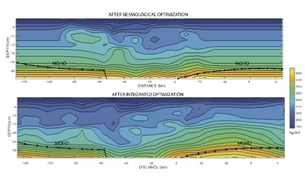 Activity 2: Joint inversions with gravity
Activity 2: Joint inversions with gravity
Computation of 3D density models from the optimization of gravity and seismic velocity data will be performed by means of Sequential Integrated Inversion (SII), to obtain maps of velocity-density relationship in the study areas and constrain the compositional variations in the crust and the possible presence of fluids. After retrieval of Bouguer gravity anomaly data at the required resolution the SII will be applied to derive regional and local-scale improved density models using the multi-scale LET velocity models obtained by Activity 1.
 |
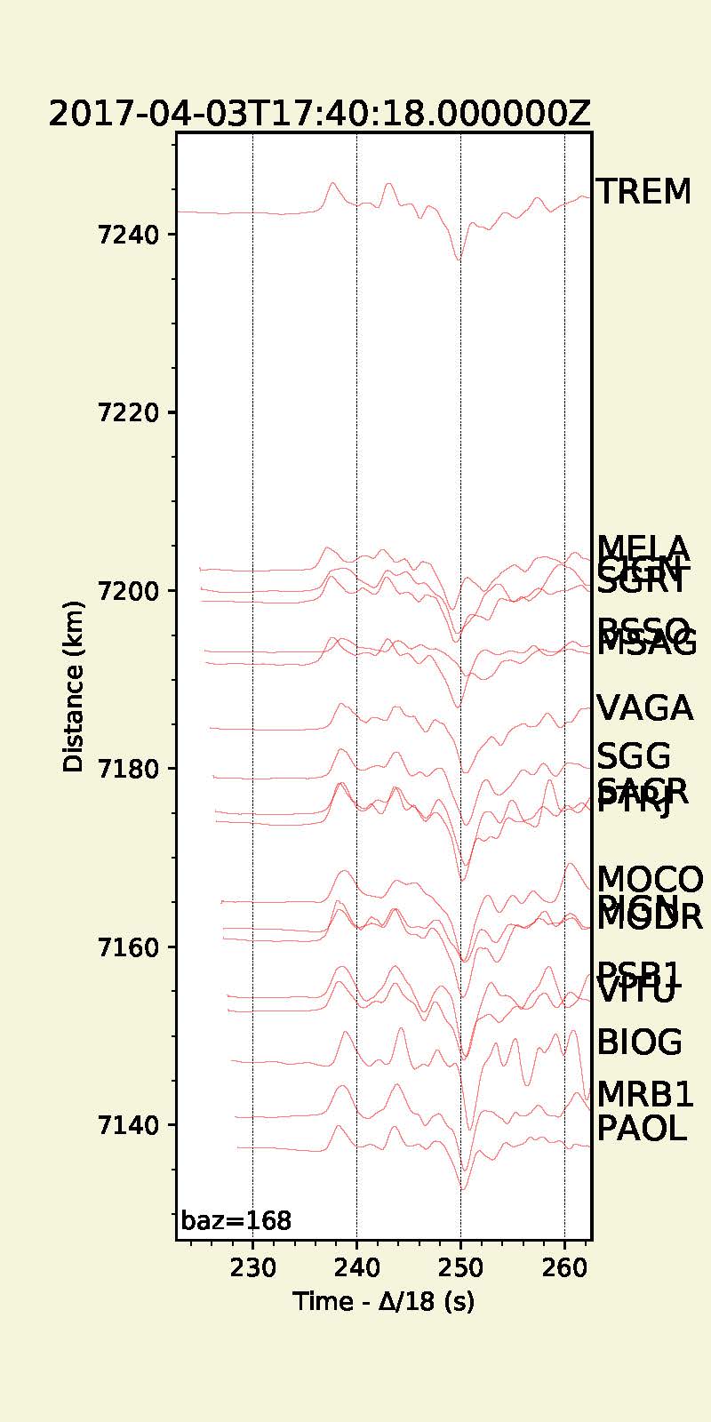 |
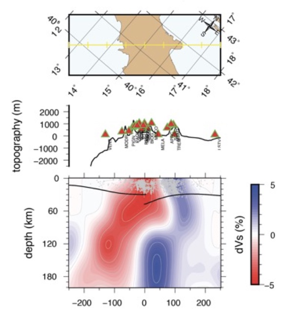
Activity 3: Body waveform analyses and modelling
Activity 3: Body waveform analyses and modeling
Broadband waveforms will be analyzed and modeled to decipher the detailed 3D geometry of slab segments and their gaps, the extent of the mantle wedge and the relative velocity contrasts at regional scale in the topmost mantle (down to about 200 km depth), a crucial depth range for understanding tectonic processes. We will exploit the observed waveform complexities and their azimuthal dependence to resolve and constrain structural features near the recording site. We will perform 2D Finite-difference modeling to reproduce simultaneously the amplitude decay and traveltime anomaly observed in the real data to:
- validate available regional-scale tomography-derived models;
- decipher the location, geometry, depth extent and velocity perturbation of specific features..
 Activity 4: Receiver Functions analyses
Activity 4: Receiver Functions analyses
Receiver Functions will provide information on:
- crustal interfaces which, combined with smooth tomographic models, will provide a structural framework for interpreting earthquake locations, and detecting and characterizing possible fluid reservoirs in the crust;
- the Moho topography and deep structure of the
Southern-Apennines, which is a challenging task due to the strong crustal discontinuities that can obscure the Moho P-s conversions and contribute to strong azimuthal variations.
Different techniques, e.g. modeling of the transverse receiver functions to detect anisotropy will be applied, depending on the results from Activities 1 to 3 and WP1.1..